Deception Pass State Park
| Deception Pass State Park | |
|---|---|

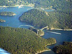
Aerial view of Deception Pass looking southeast
|
|

Located in the northern Puget Sound region, Deception Pass (circled in red) connects the Strait of Juan de Fuca (to the west) to Skagit Bay (to the east). Fidalgo Island is to the north and Whidbey Island is to the south.
|
|
| Type | State park |
| Location | Anacortes and Oak Harbor, Washington, United States |
| Created | 1922 Developed by the Civilian Conservation Corps in the 1930s |
| Operated by | Washington State Parks |
| Visitors | 2,000,000+ annually |
| Open | Year-round |
Deception Pass is a strait separating Whidbey Island from Fidalgo Island, in the northwest part of the U.S. state of Washington. It connects Skagit Bay, part of Puget Sound, with the Strait of Juan de Fuca. A pair of bridges known collectively as Deception Pass Bridge cross Deception Pass, and the bridges are on the National Register of Historic Places.
The Deception Pass area has been home to various Coast Salish tribes for thousands of years. The first Europeans to see Deception Pass were members of the 1790 expedition of Manuel Quimper on the Princesa Real. The Spanish gave it the name Boca de Flon. A group of sailors led by Joseph Whidbey, part of the Vancouver Expedition, found and mapped Deception Pass on June 7, 1792.George Vancouver gave it the name "Deception" because it had misled him into thinking Whidbey Island was a peninsula. The "deception" was heightened due to Whidbey's failure to find the strait at first. In May 1792, Vancouver was anchored near the southern end of Whidbey Island. He sent Joseph Whidbey to explore the waters east of Whidbey Island, now known as Saratoga Passage, using small boats. Whidbey reached the northern end of Saratoga Passage and explored eastward into Skagit Bay, which is shallow and difficult to navigate. He returned south to rejoin Vancouver without having found Deception Pass. It appeared that Skagit Bay was a dead-end and that Whidbey Island and Fidalgo Island were a long peninsula attached to the mainland. In June the expedition sailed north along the west coast of Whidbey Island. Vancouver sent Joseph Whidbey to explore inlets leading to the east. The first inlet turned out to be a "very narrow and intricate channel, which...abounded with rocks above and beneath the surface of the water". This channel led to Skagit Bay, thus separating Whidbey Island from the mainland. Vancouver apparently felt he and Joseph Whidbey had been deceived by the tricky strait. Vancouver wrote of Whidbey's efforts: "This determined [the shore they had been exploring] to be an island, which, in consequence of Mr. Whidbey’s circumnavigation, I distinguished by the name of Whidbey’s Island: and this northern pass, leading into [Skagit Bay], Deception Passage".
...
Wikipedia
