Dartmoor crosses
| Dartmoor | |
| Protected Area | |
|
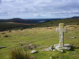
Ancient cross close to Crazywell Pool on southern Dartmoor
|
|
| Country | United Kingdom |
|---|---|
| Part | England |
| County | Devon |
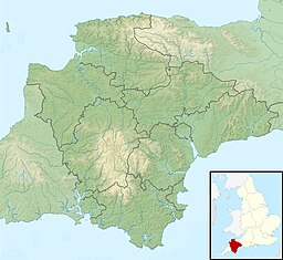
| Coordinates | 50°34′N 4°0′W / 50.567°N 4.000°WCoordinates: 50°34′N 4°0′W / 50.567°N 4.000°W |
| Highest point | High Willhays |
| - elevation | 621 m (2,037 ft) |
| Lowest point | Doghole Bridge |
| - elevation | 24 m (79 ft) |
| Area | 953 km2 (368 sq mi) |
| National Park of England | 1951 |
| Management | Dartmoor National Park Authority |
| - location | Bovey Tracey |
| Visitation | 10.98m |
| IUCN category | II - National Park |
|
Website: www |
|
The Dartmoor crosses are a series of stone crosses found in Dartmoor National Park in the centre of Devon, England. Many of them are old navigational aids, needed because of the remoteness of the moorland and its typically bad weather. Some mark medieval routes between abbeys. Other crosses were erected as memorials, for prayer, as town or market crosses, in churchyards, and as boundary markers. The crosses were erected over a long period of time, some as recently as 100 years ago, the earliest probably almost 1,000 years ago.
In 2005, the Dartmoor National Park Authority had an ongoing project to microchip the most vulnerable of its granite artifacts, including crosses, to deter theft and aid the recovery of any that might be stolen.
There is a legend attached to the origin of the original crosses. The story says that there were four monks who did not want to follow their abbot's rules on austere living. Once the abbot went to Italy, the four brothers decided to celebrate, yet they needed some money. They robbed and killed a wealthy Jew. In the same evening the brothers were called to the nearby moor, which was covered in snow and ice at the time. When they reached the place, they realized that the messenger who had beckoned them was the ghost of the murdered Jewish man.
The ghost hypnotized them, and they wandered into the mire, fell through the ice, and were sucked into the thick bog. The abbot, who knew nothing about the murder of the old Jew and assumed they had run off out of guilt when they saw him coming home, ordered that the crosses be erected to mark the tracks from one monastery to another to prevent future monks from getting lost.
This cross is by the side of the road from Moretonhampstead to Two Bridges, about 900 metres north-west of the Warren House Inn. It was probably erected at this spot for two reasons: as one of the markers of this route long before the road was built, and to mark the boundary between the parishes of Chagford and North Bovey, which runs roughly along the same line as the road. Nothing is known of the early history of the cross, although its crude shape suggests that it is very old. It was later used as a boundary marker for Headland Warren ("WB" carved on one face stands for "Warren Bounds") and as one of the bounds of the mining sett of Vitifer Mine. Its survival here is probably due to its use as a boundary marker: two similar crosses further along the road towards Two Bridges are known to have been removed in the 19th century.
...
Wikipedia


