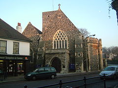
Dartford, Kent
| Dartford | |
|---|---|
 Holy Trinity Church, Dartford High Street |
|
| Dartford shown within Kent | |
| OS grid reference | TQ538739 |
| • London | 18.8 mi (30.3 km) |
| District | |
| Shire county | |
| Region | |
| Country | England |
| Sovereign state | United Kingdom |
| Post town | DARTFORD |
| Postcode district | DA1, DA2 |
| Dialling code | 01322 |
| Police | Kent |
| Fire | Kent |
| Ambulance | South East Coast |
| EU Parliament | South East England |
| UK Parliament | |
Dartford is the principal town in the Borough of Dartford, Kent, England. The town is situated on the border of Kent and Greater London, bordering the London Borough of Bexley. It also borders the Borough of Thurrock, Essex, via the Dartford Crossing of the River Thames and Gravesham to its east.
The town centre lies in a valley through which the River Darent flows, and where the old road from London to Dover crossed: hence the name, from Darent + ford. Dartford became a market town in medieval times and, although today it is principally a commuter town for Greater London, it has a long history of religious, industrial and cultural importance. It is an important rail hub; the main through-road now by-passes the town itself.
Dartford is twinned with several other towns and cities abroad including Hanau in Germany, Gravelines in France and Namyangju in South Korea.
Dartford lies within the area known as the London Basin. The low-lying marsh to the north of the town consists of London Clay, and the alluvium brought down by the two rivers—the Darent and the Cray—whose confluence is in this area. The higher land on which the town stands, and through which the narrow Darent valley runs, consists of chalk surmounted by the Blackheath Beds of sand and gravel.
...
Wikipedia

