Danbury Municipal Airport
| Danbury Municipal Airport | |||||||||||||||
|---|---|---|---|---|---|---|---|---|---|---|---|---|---|---|---|

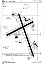
FAA airport diagram
|
|||||||||||||||
| Summary | |||||||||||||||
| Airport type | Public | ||||||||||||||
| Owner | City of Danbury | ||||||||||||||
| Serves | Danbury, Connecticut | ||||||||||||||
| Location | Danbury, Connecticut | ||||||||||||||
| Hub for | Reliant Air | ||||||||||||||
| Elevation AMSL | 458 ft / 140 m | ||||||||||||||
| Coordinates | 41°22′18″N 073°28′56″W / 41.37167°N 73.48222°WCoordinates: 41°22′18″N 073°28′56″W / 41.37167°N 73.48222°W | ||||||||||||||
| Website | DXR Website | ||||||||||||||
| Map | |||||||||||||||
| Location of airport in Connecticut/United States | |||||||||||||||
| Runways | |||||||||||||||
|
|||||||||||||||
| Statistics (2015) | |||||||||||||||
|
|||||||||||||||
|
Source: Federal Aviation Administration
|
|||||||||||||||
| Aircraft operations | 61,270 |
|---|---|
| Based aircraft | 264 |
Danbury Municipal Airport (IATA: DXR, ICAO: KDXR, FAA LID: DXR) is a public use general aviation airport located three miles (5 km) southwest of the central business district of Danbury, in Fairfield County, Connecticut, United States. The airport opened in 1930. It is currently run by the city of Danbury. It is included in the Federal Aviation Administration (FAA) National Plan of Integrated Airport Systems for 2017–2021, in which it is categorized as a regional reliever airport facility.
The Reliant Air building burned down on the evening of September 12, 2007. The hangar was located on the northeast side of the airport. It has since been rebuilt and Reliant Air continues in business.
Danbury Municipal Airport covers 248 acres (1.00 km2) and has two runways:
The airport has three instrument approaches:
For the 12-month period ending December 31, 2008, the airport had 83,419 aircraft operations, an average of 228 per day: 56% local general aviation, 40% transient general aviation, 4% air taxi and <1% military. There are 265 aircraft based at this airport: 210 single engine, 48 multi-engine, 6 jet aircraft and 1 helicopter.
...
Wikipedia


