Cuyama River
| Cuyama River | |
|
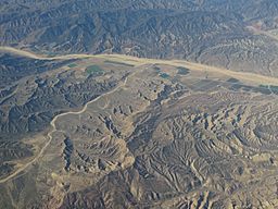
Aerial view of Cuyama River
|
|
| Country | United States |
|---|---|
| State | California |
| Tributaries | |
| - left | Santa Barbara Creek, Cottonwood Creek (Cuyama River), Mustang Creek, Pine Creek (Cuyama River) |
| - right | Quatal Creek, Huasna River |
| Source | Confluence of Alamo Creek and Dry Canyon Creek |
| - location | Near Ventucopa, Ventura County |
| - elevation | 3,807 ft (1,160 m) |
| - coordinates | 34°41′25″N 119°17′33″W / 34.69028°N 119.29250°W |
| Mouth | Santa Maria River |
| - location | near Garey, San Luis Obispo and Santa Barbara Counties |
| - elevation | 354 ft (108 m) |
| - coordinates | 34°54′11″N 120°18′45″W / 34.90306°N 120.31250°WCoordinates: 34°54′11″N 120°18′45″W / 34.90306°N 120.31250°W |
| Length | 118 mi (190 km) |
| Basin | 1,132 sq mi (2,932 km2) |
| Discharge | for Above Twitchell Reservoir |
| - average | 23.1 cu ft/s (1 m3/s) |
| - max | 26,200 cu ft/s (742 m3/s) |
| - min | 0 cu ft/s (0 m3/s) |
|
Map of the Santa Maria River watershed, including the Cuyama River
|
|
The Cuyama River (/kwiːˈjɑːmə/ kwee-YAH-mə, /kuːˈjɑːmə/ koo-YAH-mə, or /kwiːˈjæmə/ kwee-YAM-ə) is a 118-mile-long (190 km) river in southern San Luis Obispo County, northern Santa Barbara County, and northern Ventura County, in the U.S. state of California. It joins the Sisquoc River forming the Santa Maria River. The river's name comes from an Indian village named for the Chumash word kuyam, meaning "clam" or "freshwater mollusk".
...
Wikipedia


