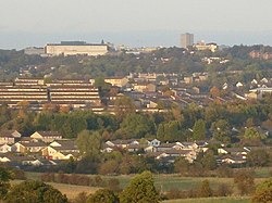
Cumbernauld, Dunbartonshire
| Cumbernauld | |
|---|---|
 Skyline of Cumbernauld |
|
| Cumbernauld shown within North Lanarkshire | |
| Population | 52,270 (2011) |
| OS grid reference | NS763736 |
| Council area | |
| Lieutenancy area | |
| Country | Scotland |
| Sovereign state | United Kingdom |
| Post town | GLASGOW |
| Postcode district | G67, G68 |
| Dialling code | 01236 |
| Police | Scottish |
| Fire | Scottish |
| Ambulance | Scottish |
| EU Parliament | Scotland |
| UK Parliament | |
| Scottish Parliament | |
Cumbernauld (/ˌkʌmbərˈnɔːld/; Scots: Cummernaud/ˌkʌmərˈnɔːd/;Scottish Gaelic: Comar nan Allt) is a town in North Lanarkshire, Scotland. It is the ninth most-populous locality in Scotland, despite only being designated as the site for a New Town on 9 December 1955. The area allocated was 4,150 acres (1,680 ha) lying between and incorporating the existing villages of Condorrat and Cumbernauld. The first new housing became available in 1958. An additional 3,638 acres (1,472 ha) was added to the designated town area on 19 March 1973 to accommodate a revised target population of 70,000. As of the UK census in 2011, the population of Cumbernauld was approximately 52,000.
Cumbernauld's history stretches to Roman times, with a settlement near the Antonine Wall, the furthest and most northerly boundary of the Roman Empire. The security that the wall gave from possibly hostile tribes to the north probably allowed the foundation of a settlement.
...
Wikipedia

