Cullercoats
| Cullercoats | |
|---|---|
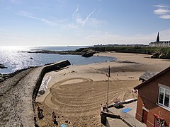
 View of Cullercoats Bay from the north. The spire of St George's Cullercoats is visible at right |
|
| Cullercoats shown within Tyne and Wear | |
| Population | 9,202 |
| OS grid reference | NZ3621571133 |
| Metropolitan borough | |
| Metropolitan county | |
| Region | |
| Country | England |
| Sovereign state | United Kingdom |
| Post town | NORTH SHIELDS |
| Postcode district | NE30 |
| Dialling code | 0191 |
| Police | Northumbria |
| Fire | Tyne and Wear |
| Ambulance | North East |
| EU Parliament | North East England |
| UK Parliament | |
Cullercoats is an urban area of North East England, with a population 9,407 in 2004. It has now been absorbed into the North Tyneside conurbation, sitting between Tynemouth and Whitley Bay.The population of this North Tyneside ward at the 2011 census was 9,202.
There is a semi-circular sandy beach with cliffs and caves, and the village is a popular destination for day-trippers. The name is thought to derive from Dove (or Culver) Cotes.
Cullercoats village was founded in 1539. Historically the village depended on fishing; there was also local coal mining in so-called bell pits. The coal was used to fire salt pans (now long gone) on the field now known as the boat field. As a port, Cullercoats was used to export both salt and coal. A new harbour and pier were constructed in 1682 and a waggonway which brought coal to the village from inland workings was added in 1690. These innovations resulted in a flourishing trade. However, the salt industry declined and the growth of the railways led to coal shipments being relocated to better harbours. By 1710 the pier had been severely damaged and the waggonway's condition had deteriorated. The last salt pans moved to Blyth in 1726. This left fishing as the main industry and two piers were built on either side of the harbour in the 19th century to provide shelter for the many open top fishing vessels, or cobles, launched from the harbour.
The harbour is the home of the Dove Marine Laboratory of 1897, a research and teaching laboratory which forms part of the School of Marine Science and Technology within Newcastle University.
In 1848, a coble taking a pilot to a ship further out at sea capsized with the loss of all on board. In response to this disaster the local landowner, the Duke of Northumberland funded the setting up of an RNLI lifeboat station. The following year a second disaster, this time costing 20 lifeboat crew their lives, prompted the Duke to sponsor a competition to design a self-righting lifeboat. The resulting boat, the Percy was built at the Duke's expense and delivered to Cullercoats in 1852. The Brigade House and watchtower were designed by Newcastle upon Tyne-based architect Frank West Rich in 1877–79, but the lifeboat station remained in use, with a few minor alterations, until 2003 when a new station was opened.
...
Wikipedia

