Cullacabardee, Western Australia
|
Cullacabardee Perth, Western Australia |
|||||||||||||
|---|---|---|---|---|---|---|---|---|---|---|---|---|---|

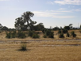
View east of Cullacabardee
|
|||||||||||||
| Coordinates | 31°48′54″S 115°54′36″E / 31.815°S 115.91°ECoordinates: 31°48′54″S 115°54′36″E / 31.815°S 115.91°E | ||||||||||||
| Population | 132 (2011 census) | ||||||||||||
| • Density | 10.2/km2 (26.3/sq mi) | ||||||||||||
| Postcode(s) | 6067 | ||||||||||||
| Area | 13 km2 (5.0 sq mi) | ||||||||||||
| Location | 21 km (13 mi) from Perth City | ||||||||||||
| LGA(s) | City of Swan | ||||||||||||
| State electorate(s) | West Swan | ||||||||||||
| Federal Division(s) | Cowan | ||||||||||||
|
|||||||||||||
Cullacabardee is a northeastern rural suburb of Perth, the capital city of Western Australia, located 21 km (13 mi) from Perth's central business district via Alexander Drive or Beechboro Road. It is in the City of Swan local government area. Most of the suburb is covered in native sheoak and banksia forest. A small Noongar Aboriginal community is based on Baal Street, a drug rehabilitation retreat is located off Gnangara Road in the suburb's northeast, and the Perth International Telecommunications Centre facility is based in the suburb's northwest.
Cullacabardee is 21 kilometres (13 mi) north of Perth's central business district, beyond the residential suburb of Ballajura. It covers approximately 13 square kilometres (5 sq mi)) and its borders are Gnangara Road ![]() to the north, Alexander Drive
to the north, Alexander Drive ![]() to the west, Beechboro Road
to the west, Beechboro Road ![]() to the east and Hepburn Avenue to the south. Only one public road, Baal Street, enters the locality.
to the east and Hepburn Avenue to the south. Only one public road, Baal Street, enters the locality.
...
Wikipedia

