Croydon, Surrey
| Croydon | ||||
|---|---|---|---|---|
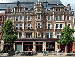
From top to bottom: the Old Town Hall and Clocktower (with the Spreadeagle in the foreground), Katharine Street; the Grants Building, High Street
|
||||
| Croydon shown within Greater London | ||||
| Population | 173,314 (Addiscombe, Broad Green, Fairfield, Waddon, Croham, Selhurst, Ashburton, Woodside, Sanderstead, Shirley and Selsdon and Ballards wards) | |||
| OS grid reference | TQ335655 | |||
| • Charing Cross | 9.5 mi (15.3 km) N | |||
| London borough | ||||
| Ceremonial county | Greater London | |||
| Region | ||||
| Country | England | |||
| Sovereign state | United Kingdom | |||
| Post town | CROYDON | |||
| Postcode district | CR0 CR9 CR2 CR7 | |||
| Dialling code | 020 | |||
| Police | Metropolitan | |||
| Fire | London | |||
| Ambulance | London | |||
| EU Parliament | London | |||
| UK Parliament | ||||
| London Assembly | ||||
Croydon is a large town in south London, England, the principal settlement of the London Borough of Croydon. It is located 9.5 miles (15.3 km) south of Charing Cross. It is one of the largest commercial districts outside of Central London, bearing one of the largest shopping districts and a developed night-time economy. It is identified in the London Plan as one of 11 metropolitan centres in Greater London. It has a population of 52,104 in the 2011 census, comprising the Addiscombe, Broad Green and Fairfield wards.
Historically a part of the hundred of Wallington in the county of Surrey, at the time of the Norman conquest of England, Croydon had a church, a mill, and around 365 inhabitants, as recorded in the Domesday Book of 1086. Croydon expanded during the Middle Ages as a market town and a centre for charcoal production, leather tanning and brewing. The Surrey Iron Railway from Croydon to Wandsworth opened in 1803 and was the world's first public railway. Later nineteenth century railway building facilitated Croydon's growth as a commuter town for London (including the City of London). By the early 20th century, Croydon was an important industrial area, known for car manufacture, metal working and its airport. In the mid 20th century these sectors were replaced by retailing and the service economy, brought about by massive redevelopment which saw the rise of office blocks and the Whitgift Centre, for many decades the largest shopping centre in Greater London until 2008. Croydon was amalgamated into Greater London in 1965, but is still considered by some to be part of Surrey because of the postal county.
...
Wikipedia


