Croydon, New Hampshire
| Croydon, New Hampshire | |
|---|---|

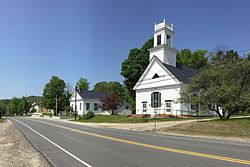
Croydon town center: Town Hall on left, First Congregational Church on right
|
|
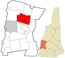
 Location in Sullivan County and the state of New Hampshire. |
|
| Coordinates: 43°27′02″N 72°09′47″W / 43.45056°N 72.16306°WCoordinates: 43°27′02″N 72°09′47″W / 43.45056°N 72.16306°W | |
| Country | United States |
| State | New Hampshire |
| County | Sullivan |
| Incorporated | 1763 |
| Government | |
| • Board of Selectmen | James Harding Carol Marsh George Caccavaro |
| Area | |
| • Total | 37.5 sq mi (97.0 km2) |
| • Land | 36.7 sq mi (95.0 km2) |
| • Water | 0.8 sq mi (2.0 km2) 2.06% |
| Elevation | 892 ft (272 m) |
| Population (2010) | |
| • Total | 764 |
| • Density | 20/sq mi (7.9/km2) |
| Time zone | Eastern (UTC-5) |
| • Summer (DST) | Eastern (UTC-4) |
| ZIP code | 03773 |
| Area code(s) | 603 |
| FIPS code | 33-16340 |
| GNIS feature ID | 0873572 |
Croydon is a town in Sullivan County, New Hampshire, United States. The population was 764 at the 2010 census.
Incorporated in 1763, the town takes its name from Croydon, a suburb of London, England..
Croydon was home to Ruel Durkee, a powerful 19th century political boss in the state. The town of "Coniston" in the best-selling novel of 1906 is based on Croydon, and Durkee was portrayed as "Jethro Bass". The local "Coniston General Store" is named after the novel.
According to the United States Census Bureau, the town has a total area of 37.5 square miles (97.1 km2), of which 36.7 square miles (95.1 km2) is land and 0.8 square miles (2.1 km2) is water, comprising 2.06% of the town. The highest point in town is Croydon Peak, at 2,760 feet (840 m) above sea level. Croydon lies fully within the Connecticut River watershed.
Croydon is home to Corbin Park, one of the largest private game reserves in New England. The 24,000-acre (9,700 ha) fenced-in expanse of woodlands and mountainous terrain features bison, European boar and elk and extends into neighboring towns.
As of the census of 2000, there were 661 people, 264 households, and 194 families residing in the town. The population density was 17.8 people per square mile (6.9/km²). There were 354 housing units at an average density of 9.5 per square mile (3.7/km²). The racial makeup of the town was 97.43% White, 0.45% Native American, 0.15% Asian, 0.76% from other races, and 1.21% from two or more races. Hispanic or Latino of any race were 0.61% of the population.
...
Wikipedia
