Crowland
| Crowland | |
|---|---|
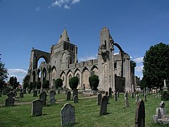
 Crowland Abbey |
|
| Crowland shown within Lincolnshire | |
| Population | 4,211 (2011.Parish) |
| OS grid reference | TF2410 |
| • London | 80 mi (130 km) S |
| District | |
| Shire county | |
| Region | |
| Country | England |
| Sovereign state | United Kingdom |
| Post town | PETERBOROUGH |
| Postcode district | PE6 |
| Dialling code | 01733 |
| Police | Lincolnshire |
| Fire | Lincolnshire |
| Ambulance | East Midlands |
| EU Parliament | East Midlands |
| UK Parliament | |
Crowland (modern usage) or Croyland (medieval era name and the one still in ecclesiastical use) is a small town in the South Holland district of Lincolnshire, England. It is situated between Peterborough and Spalding. Crowland contains two sites of historical interest, Crowland Abbey and Trinity Bridge
The town's two historical points of interest are the ruined medieval Crowland Abbey and the 14th-century three-sided bridge, Trinity Bridge, which stands at its central point and used to be the confluence of three streams.
In about 701 a monk named Guthlac came to what was then an island in the Fens to live the life of a hermit. Following in Guthlac’s footsteps, a monastic community came into being here, which was dedicated to Saint Mary the Virgin, Saint Bartholomew and Saint Guthlac in the eighth century. The Croyland Chronicle, an important source for medieval historians, is believed to be the work of some of the monastery's inhabitants. Marshland beside the island was drained and a town gradually grew up near the abbey.
During the English Civil War, the town was captured after a short siege by Parliamentarian forces in 1643.
The surrounding agricultural area suffered from extensive flooding in 1947 as the River Welland and the surrounding drain network was overwhelmed with meltwater. A flood defence bank, West Bank, still exists, forming the north-west perimeter of the village and eastern flank of the River Welland's flood plain.
...
Wikipedia

