Crow Wing State Park
| Crow Wing State Park | |
| Minnesota State Park | |
|
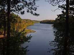
The Mississippi River from Chippewa Lookout in Crow Wing State Park
|
|
| Country | United States |
|---|---|
| State | Minnesota |
| Counties | Cass, Crow Wing, Morrison |
| Location | Brainerd |
| - elevation | 1,158 ft (353 m) |
| - coordinates | 46°16′20″N 94°20′00″W / 46.27222°N 94.33333°WCoordinates: 46°16′20″N 94°20′00″W / 46.27222°N 94.33333°W |
| Area | 3,119 acres (1,262 ha) |
| Founded | 1959 |
| Management | Minnesota Department of Natural Resources |
|
Crow Wing State Park
|
|

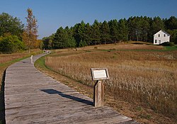
Townsite of Old Crow Wing, with the Clement Beaulieu House in the distance
|
|
| Location | Fort Ripley Township, Crow Wing County, Minnesota |
|---|---|
| NRHP Reference # | 70000288 |
| Added to NRHP | July 28, 1970 |
Crow Wing State Park is a state park of Minnesota, United States, at the confluence of the Mississippi and Crow Wing Rivers. The park interprets the site of Old Crow Wing, one of the most populous towns in Minnesota in the 1850s and 1860s. The entire park was added to the National Register of Historic Places in 1970. A section of the Red River Trails that passed through Old Crow Wing is also separately listed on the National Register.
The park lies on an outwash plain formed from the outwash of Glacial Lake Grantsburg. The present-day vegetation is oak forest with red, white, and jack pine; and aspen, with prairie and wetland openings.
It is home to wildlife species such as coyote, white-tailed deer, eagle, beaver, hawk, muskrat, waterfowl, fox, and various songbirds.
The confluence of the Crow Wing and Mississippi Rivers formed a natural crossroads, attracting humans with its easy travel routes and quality hunting. At the beginning of the historical period the region was inhabited by Dakota, who clashed with Ojibwe being displaced from farther east. It is told that in 1768 a Dakota war party raided an Ojibwe village and carried off several women in their canoes. The village's warriors, returning from their own unsuccessful raid, laid an ambush on a high bank over the river, digging shallow pits from which to fire their rifles. As the Dakota convoy passed under the Ojibwe, the men opened fire, while the captured women overturned the canoes they were in and swam for shore. The Dakota regrouped and counterattacked by land, but were repulsed. The two-day battle cemented Ojibwe control over the area.
...
Wikipedia


