Crofton, West Yorkshire
| Crofton | |
|---|---|
 |
|
| Crofton shown within West Yorkshire | |
| Population | 5,781 (2011) |
| OS grid reference | SE374182 |
| Civil parish |
|
| Metropolitan borough | |
| Metropolitan county | |
| Region | |
| Country | England |
| Sovereign state | United Kingdom |
| Post town | WAKEFIELD |
| Postcode district | WF4 |
| Dialling code | 01924 |
| Police | West Yorkshire |
| Fire | West Yorkshire |
| Ambulance | Yorkshire |
| EU Parliament | Yorkshire and the Humber |
| UK Parliament | |
Crofton is a village near Wakefield in West Yorkshire, England, about 4 miles (6 km) south-east of the city, some 6 miles (10 km) to the west of the town of Pontefract, and 4 miles (6 km) from the town of Featherstone. The population of the civil parish at the time of the 2011 census was 5,781.
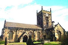
Crofton is listed in the Domesday Book as Scroftune. The village has one church: the Anglican church was built around 1430. A Roman Catholic church built in the 1920s closed in 2008. Crofton New Hall was built in the 1750s for the Wilsons who lived in the village until 1935 when the Colonel sold the manor house and the estate and moved away from the village. During the Second World War, the hall was used by the army, later the Coal Board, then became Brown's Tutorial School, closed in 1980 to be demolished. Shortly afterwards, a new housing estate built there. Some of the Wilson family are buried in a large mausoleum in the cemetery.
Crofton was predominantly a farming community, but the mining of coal became important in the 19th century and continued until the 1980s. There were three coal mines within a two-mile radius of the village, these mines being Nostell, Walton and Sharlston. By the early 1900s, Lord St Oswald had built houses at New Crofton, known locally as both Cribbens and Scribbens Lump, for the workers of Nostell Mine. This area was populated until the 1980s when they were demolished along with the mines. 'The Lump' also had a mission hall, a local shop and a fish and chip shop, the fish and chip shop in question was known locally as "The Leaning Chippy" due to the subsidence from the local mines at Nostell. In the 1970s, there were two shops near the lump, "Alf's" which was a corner shop located where the Slipper public house is today and the other shop, also the local car garage "Mrs Moody's". There is also an old, disused well from which villagers used to get their water supplies many years ago: the well is still there but has since been filled in due to it being a hazard for local children.
The houses from "The Lump" as it was known were demolished due to severe subsidence from the mine at nostell, it was simply cheaper to demolish the houses and rebuild rather than to repair the damage the subsidence had caused. Once it was demolished, the area was a wasteland for many years, but the old cobble streets and roads were still visible and eventually the land was sold and a new housing estate was built on it. Most of the old subsidence would have stopped by now with many of the old mines being collapsed and filled in years ago but some still remain and will affect the surrounding areas for years to come.
There is a rumour that when the miners at Nostell pit were clearing new coal seams, they came across what was described as an underground church, which the monks from Nostell Priory had built years before. This church was complete with tunnels, which the monks used to use for transporting coal to the monastery. The church had wooden doors and seating inside, exactly why they built it there underground and for what reason may never be known. The entrance and tunnel was eventually sealed. Local miner and Nostell safety man Leslie Simpson Snr and a fellow miner carved their names into the wood of the church door just before the tunnel was sealed. One theory is that the monks built the underground church to pray and worship in private, the monastery which was built on Nostell Priory was dissolved by Henry VIII in 1540 and this could possibly explain the existence of the underground church.
...
Wikipedia

