Creech Barrow Hill
| Creech Barrow Hill | |
|---|---|

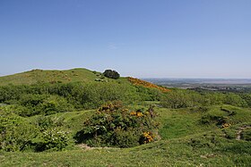
Creech Barrow Hill seen from the area of Stonehill Down to the south
|
|
| Highest point | |
| Elevation | 193 m (633 ft) |
| Prominence | 38 m (125 ft) |
| Parent peak | Swyre Head |
| Listing | Tump |
| Coordinates | 50°38′29.48″N 2°6′37.16″W / 50.6415222°N 2.1103222°WCoordinates: 50°38′29.48″N 2°6′37.16″W / 50.6415222°N 2.1103222°W |
| Geography | |
| Location | Dorset, England |
| Parent range | Dorset Heaths |
| OS grid | SY921823 |
| Topo map | OS Landranger 195 |
| Geology | |
| Mountain type | Cenozoic |
Creech Barrow Hill is a steep, conical hill, 193 metres (633 ft) (one source 637 feet) high, near the coast of Dorset, England, and the highest point of the Dorset Heaths. It has been described as "one of Dorset's most distinctive landmarks." Geologically, it is also the highest Cenozoic hill in England.
There is a single, round barrow at the summit that gives Creech Barrow Hill its name and, from some angles, the appearance of a double summit. To the southeast is Stone Hill Down long barrow. There is also a trig point on the summit.
The name of the hill means "hill" three times. "Creech" is derived from the Celtic crich = hill and "barrow" from the Saxon for "mound".
The hill is a classic viewpoint that was once the site of King John's hunting lodge.
...
Wikipedia
