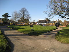
Creaton
| Creaton | |
|---|---|
 Creaton Village Green |
|
| Creaton shown within Northamptonshire | |
| Population | 503 (2011 Census) |
| OS grid reference | SP707719 |
| • London | 73 miles (117 km) |
| Civil parish |
|
| District | |
| Shire county | |
| Region | |
| Country | England |
| Sovereign state | United Kingdom |
| Post town | NORTHAMPTON |
| Postcode district | NN6 |
| Dialling code | 01604 |
| Police | Northamptonshire |
| Fire | Northamptonshire |
| Ambulance | East Midlands |
| EU Parliament | East Midlands |
| UK Parliament | |
Creaton is a village and civil parish in the Daventry district of the shire county of Northamptonshire, England.
The village is 8 miles (13 km) north-west of the town of Northampton and 18 miles (29 km) south-east of the city of Leicester, along the A5199, formerly designated as the A50 trunk road. The road is known as Welford Road in the village and runs along the top of the ridge on which the village stands giving it extensive views east and west. About 5 miles (8 km) north on the road the A5199 connects with the A14 trunk road, a dual carriageway connecting the M1 and M6 motorways from the Catthorpe Interchange with Kettering, Cambridge, Ipswich and the port of Felixstowe.
The village has its own Parish Council and is part of Daventry Parliamentary Constituency. The Daventry constituency has been represented by a member of the Conservative Party since 1974.
The local district council is Daventry District Council where Creaton is in Spratton ward together with the villages of Cottesbrooke, Spratton itself and surrounding rural areas. The village is in the Northamptonshire County Council area.
...
Wikipedia

