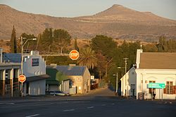
Cradock, Eastern Cape
| Cradock | |
|---|---|

Cradock
|
|
|
|
|
| Coordinates: 32°11′S 25°37′E / 32.183°S 25.617°ECoordinates: 32°11′S 25°37′E / 32.183°S 25.617°E | |
| Country | South Africa |
| Province | Eastern Cape |
| District | Chris Hani |
| Municipality | Inxuba Yethemba |
| Established | 1816 |
| Area | |
| • Total | 125.96 km2 (48.63 sq mi) |
| Population (2011) | |
| • Total | 36,671 |
| • Density | 290/km2 (750/sq mi) |
| Racial makeup (2011) | |
| • Black African | 61.8% |
| • Coloured | 25.4% |
| • Indian/Asian | 0.4% |
| • White | 11.8% |
| • Other | 0.5% |
| First languages (2011) | |
| • Xhosa | 55.9% |
| • Afrikaans | 38.2% |
| • English | 3.5% |
| • Other | 2.4% |
| Postal code (street) | 5880 |
| PO box | 5880 |
| Area code | 048 |
Cradock is a town in the Eastern Cape Province of South Africa, in the upper valley of the Great Fish River, 250 kilometres (160 mi) by road northeast of Port Elizabeth. The town is the administrative seat of the Inxuba Yethemba Local Municipality in the Chris Hani District of the Eastern Cape. The estimated population in 2015 was 35,000.
For thousands of years San hunter-gatherers were the sole human inhabitants of southern Africa. About 2000 years BP the semi-nomadic Khoikhoi (or Khoekhoen or Khoikhoin) arrived with cattle, sheep and goats. These pastoralists migrated south towards the coast. Rock paintings and petroglyphs (engravings) remain as evidence of the first people who lived here.
By the 4th century AD Bantu-speaking people had begun to migrate from central Africa down the east coast into southern Africa. The amaXhosa pressed further south to the banks of the Great Fish River where they met San hunter-gatherers and Khoikhoi pastoralists, and later still Dutch and then British settlers.
The district of which Cradock is now the centre was first settled by Dutch farmers in the late 18th century, but was known long before to the hunters who illicitly crossed the frontier in search of game and ivory.
The first official Dutch expedition to the upper Great Fish River was in mid-1752 when a party led by Ensign August Frederik Beutler visited the area. Beutler, following the instructions of Governor Ryk Tulbagh to investigate the possibilities of developing the Cape's eastern regions, was accompanied by a number of other officials including a diarist, Carl Haupt, and a surveyor, Carl Wentzel, who drew a map of the route taken. Almost the only mention made about the area in the diary was that it was very dry and forage was unobtainable.
Forty five years later traveller Sir John Barrow crossed the Great Fish River. At his crossing point he noted on his map the existence beside the river of "Hepatic wells" - sulphur springs. In later years the springs were to be used for wool washing and the town's laundry.
...
Wikipedia


