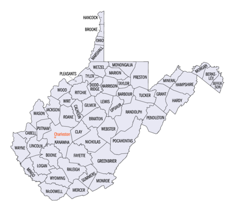
Counties of West Virginia
| Counties of West Virginia | |
|---|---|
| Location | State of West Virginia |
| Number | 55 |
| Populations | 5,717 (Wirt) – 193,063 (Kanawha) |
| Areas | 83 square miles (210 km2) (Hancock) – 1,040 square miles (2,700 km2) (Randolph) |
| Government | County government |
| Subdivisions | cities, towns, unincorporated communities, census designated place |
The U.S. state of West Virginia has 55 counties. Fifty of them existed at the time of the Wheeling Convention in 1861, before which West Virginia was part of the Commonwealth of Virginia. The remaining five (Grant, Mineral, Lincoln, Summers and Mingo) were formed within the state after its admission to the United States on June 20, 1863. At that time, Berkeley County and Jefferson County, the two easternmost counties of West Virginia, refused to recognize their inclusion in the state. In March 1866, the United States Congress passed a joint mandate assenting to their inclusion.
The West Virginia Constitution was ratified in 1872, replacing the state constitution created in 1863 when West Virginia became a state. Article 9, Section 8, of the West Virginia Constitution permits the creation of additional counties if a majority of citizens in the proposed new county vote for its creation and the new county has a minimum area of 400 square miles (1,036 km2) and a population of at least 6,000. Creation of a new county is prohibited if it would bring another county below these thresholds. Three counties (Greenbrier, Kanawha and Randolph) have sufficient population and land area to allow a new county to be split off. The remaining counties cannot be split, as either their land area would decrease to under 400 square miles (1,036 km2) or their population would decrease to under 6,000. Population figures are based on the 2010 United States Census.
...
Wikipedia


