Coto Brus (canton)
| Coto Brus | ||
|---|---|---|

The surrounding topography of San Vito
|
||
|
||
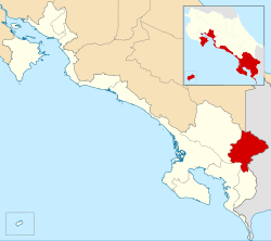
 Location of Coto Brus Canton in Puntarenas Province |
||
| Coordinates: 08°53′41″N 82°54′58″W / 8.89472°N 82.91611°WCoordinates: 08°53′41″N 82°54′58″W / 8.89472°N 82.91611°W | ||
| Canton | Coto Brus | |
| Canton | Coto Brus | |
| Province | Puntarenas | |
| Country | Costa Rica | |
| Founded | 10 December 1965 | |
| Government | ||
| • Mayor | Rafael Angel Navarro Umaña | |
| Area | ||
| • Total | 933.91 km2 (360.58 sq mi) | |
| Population (2013) | ||
| • Total | 43,660 | |
| • Density | 47/km2 (120/sq mi) | |
| Demonym(s) | Cotobruseño/a | |
| Time zone | UTC-6 | |
| Website | www.cotobrus.net | |
Coto Brus is the eighth canton in the province of Puntarenas in Costa Rica. The canton covers an area of 933.91 km², and has a population of 43,660. Its capital city is San Vito.
The upland canton shares its eastern border with Panama. The northern limit is high in the Cordillera de Talamanca, and the southwestern boundary runs through the Fila Zapote, one of many small coastal mountain ranges inland from Costa Rica's Pacific coast.
The canton of Coto Brus is subdivided into 5 distritos (districts).
The canton was created by law on December 10, 1965. more in http://www.cotobrus.net
...
Wikipedia

