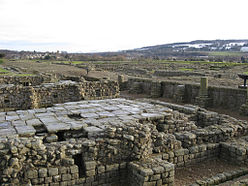
Coria (Corbridge)
| Coria (Corbridge) | |
|---|---|
 |
|
| Alternative name(s) | Coriosopitum, Corsopitum or Corsobetum |
| Founded | c. 84 AD |
| Province | Britannia |
| — Stone structure — | |
| — Wood and earth structure — | |
| Built | c. 84 AD |
| — Alae — | |
| I Petriana ? | |
| Coordinates | 54°58′42″N 2°01′59″W / 54.9784°N 2.03316°W |
| County | Northumberland |
| Country | England |
| UK-OSNG reference | NY981647 |
| Condition | Ruined |
Coordinates: 54°58′42″N 2°01′59″W / 54.9784°N 2.03316°W
Coria was a fort and town, located 2.5 miles (4.0 km) south of Hadrian's Wall, in the Roman province of Britannia at a point where a major Roman North-South road (Dere Street) bridged the River Tyne and met another Roman road (Stanegate), which ran East-West between Coria and Luguvalium (the modern Carlisle) in the Solway Plain . Its full Latin name is uncertain. Today it is known as Corchester or Corbridge Roman Site, adjoining Corbridge in the English county of Northumberland. It is currently in the guardianship of English Heritage and is partially exposed as a visitor attraction, including a site museum.
The place-name appears in contemporary records as both Corstopitum and Corie Lopocarium. These forms are generally recognised as corrupt. Suggested reconstructions include Coriosopitum, Corsopitum or Corsobetum. However, the Vindolanda tablets show that it was locally referred to by the simple form, Coria, the name for a local tribal centre. The suffix ought to represent the name of the local tribe, a member of the Brigantian confederation, but its correct form is, as yet, unknown. It subsequently gave its name to Corbridge, albeit by processes which are debated.
...
Wikipedia

