Coquille River
| Coquille River | |
|
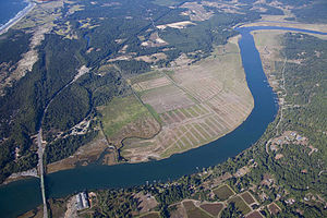
Aerial view of the Coquille near its mouth
|
|
| Country | United States |
|---|---|
| State | Oregon |
| County | Coos |
| Source | Southern Oregon Coast Range |
| - location | Myrtle Point |
| - elevation | 17 ft (5 m) |
| - coordinates | 43°04′49″N 124°08′28″W / 43.08028°N 124.14111°W |
| Mouth | Pacific Ocean |
| - location | Bandon, Oregon |
| - elevation | 0 ft (0 m) |
| - coordinates | 43°07′25″N 124°25′48″W / 43.12361°N 124.43000°WCoordinates: 43°07′25″N 124°25′48″W / 43.12361°N 124.43000°W |
| Length | 36.3 mi (58 km) |
| Basin | 1,059 sq mi (2,743 km2) |
| Discharge | |
| - average | 4,526 cu ft/s (128 m3/s) |
The Coquille River is a stream, about 36 miles (58 km) long, in southwestern Oregon in the United States. It drains a mountainous area of 1,059 square miles (2,740 km2) of the Southern Oregon Coast Range into the Pacific Ocean. Its watershed is between that of the Coos River to the north and the Rogue River to the south.
The river, formed by the confluence of its north and south forks, begins at Myrtle Point. The North Fork Coquille River, about 53 miles (85 km) long), rises in northern Coos County and flows southwest. The East Fork Coquille River, about 34 miles (55 km) long, rises in eastern Coos County, and flows generally west to join the North Fork.
The South Fork, about 63 miles (101 km) long, rises in southern Coos County, north of the Wild Rogue Wilderness Area, and flows generally north. It receives the Middle Fork Coquille River, about 40 miles (64 km) long, then joins the North Fork from the south at Myrtle Point. The combined river meanders generally west, past Coquille. It enters the Pacific at Bandon, about 20 miles (32 km) north of Cape Blanco.
Named tributaries of the Coquille River from source to mouth are the North Fork and South Fork followed by Grady, Hall, Gray, Fishtrap, Glen Aiken, Pulaski, Rink, Fat Elk, Calloway, and China creeks. Next come Beaver, Iowa, and Hatchet sloughs followed by Alder, Lampa, Lowe, and Bear creeks. Further downstream Offield Creek enters via Randolph Slough. Then come Sevenmile and Fahys creeks followed by Peterson Gulch. Below that are Spring, Simpson, and Ferry creeks.
...
Wikipedia


