Coonabarabran
|
Coonabarabran New South Wales |
|||||||
|---|---|---|---|---|---|---|---|

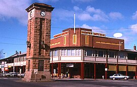
Town centre/ Imperial Hotel
|
|||||||
| Coordinates | 31°15′S 149°16′E / 31.250°S 149.267°ECoordinates: 31°15′S 149°16′E / 31.250°S 149.267°E | ||||||
| Population | 2,609 (2011 census) | ||||||
| Postcode(s) | 2357 | ||||||
| Elevation | 505 m (1,657 ft) | ||||||
| Location | |||||||
| LGA(s) | Warrumbungle Shire | ||||||
| State electorate(s) | Barwon | ||||||
| Federal Division(s) | Parkes | ||||||
|
|||||||
Coonabarabran /kuːnəˈbærəbrən/ is a town in Warrumbungle Shire that sits on the divide between the Central West and North West Slopes regions of New South Wales, Australia. At the 2011 census, the town had a population of 3,175. The town's nickname is "Coona".
In 1817 the area was opened up by a Government-sponsored expedition. In 1818 John Oxley found Aboriginal people living here — later identified as the western language reach of the Kamilaroi clans (Gamilaraay is the spelling used by linguists). Kamilaroi people are still well represented in the region, having occupied Coonabarabran for approximately 7,500 years.
In 1859 Lewis Gordon first proposed a town plan survey for Coonabarabran.
Nobody really seems to know the source and meaning of the word Coonabarabran. It may derive from a person's name or from the Kamilaroi language word 'gunbaraaybaa' meaning 'excrement', translated earlier as meaning, 'peculiar odour', this possibly is a bowdlerisation. Another meaning is derived from an Aboriginal word for 'inquisitive person'. 'Coolabarabran' was the name of a station owned by James Weston in 1848.
Coonabarabran Post Office opened on 1 January 1850.
Coonabarabran Memorial Clock Tower is a central feature of the town, in the intersection of John Street and Dalgarno Street. It was built from local sandstone and dedicated in 1928.
Coonabarabran is the gateway to the Warrumbungle National Park and the Pilliga Forest.
...
Wikipedia

