Constitution Island
| Constitution Island | |
|---|---|

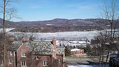
Constitution Island, NY as seen looking east from Merritt Road, on West Point
|
|
|
Location within New York
|
|
| Nearest city | West Point, New York |
| Coordinates | 41°24′20″N 73°57′15″W / 41.40556°N 73.95417°WCoordinates: 41°24′20″N 73°57′15″W / 41.40556°N 73.95417°W |
Constitution Island is located on the east side of the Hudson River directly opposite the U.S. Military Academy Reservation and is connected to the east shore by Constitution Marsh.
It is the only part of the U.S. Military Academy Reservation on the east side of the Hudson River. Constitution Island is the site of the earliest Revolutionary War fortifications in the Hudson Valley. Taken briefly by the British in 1777, the island was re-occupied by American forces in 1778, and made an integral part of Fortress West Point.. Formerly known as "Martelaer's Rock", It is the site of the earliest Revolutionary War fortifications in the Hudson Valley. The island was given to the United States of America in 1909, and since then has been administered by the West Point Museum at the United States Military Academy.
Between Cold Spring and West Point lay a large rocky island connected to the eastern shore by a reedy marsh. Dutch Navigator's called it Martelaer's Island and the part of the river between it and Storm King Mountain, Martelaer's Rack, or Martyr's Reach. The word "martyr" signified "struggling", as vessels coming up the river with a fair wind would frequently find themselves, immediately after passing the point of the island into the reach, contending with the wind ahead.
The strategic importance of the ability to control navigation along the Hudson River was obvious to both the Americans and the British from the outbreak of open hostilities. The Hudson was the major means for transportation of supplies and troops throughout a large portion of the northeast. On May 25, 1775 the Continental Congress resolved to build fortifications in the Hudson highlands for the purpose of protecting and maintaining control of the Hudson River.
General George Washington was appointed by the Continental Congress to work with the New York Provincial Congress to draft plans as to how the Hudson River should be fortified against the British. Local residents James Clinton and Christopher Tappan were sent to scout appropriate locations. The initial site chosen was Martlaer's Island, across from West Point. Located on a strategic curve in the Hudson River, engineer Bernard Romans, was appointed to begin the construction of a large fort on the island which was to be named “Fort Constitution".
...
Wikipedia

