Colorado Boulevard

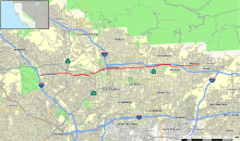
Map of Los Angeles County in southern California with Colorado Boulevard highlighted in red
|
|
| West end |
|
|---|---|
| Major junctions |
Arroyo Parkway ( |
| East end | Shamrock Ave in Monrovia, California |
Colorado Boulevard (or Colorado Street) is a major east–west street in Southern California. It runs from Griffith Park in Los Angeles east through Glendale, the Eagle Rock section of Los Angeles, Pasadena, and Arcadia, ending in Monrovia. The full route was once various state highways but is now locally maintained in favor of the parallel Ventura Freeway (CA-134) and Foothill Freeway (I-210).
Colorado Street begins at Interstate 5 (Golden State Freeway) as a short freeway spur, originally carrying State Route 134 until it was moved north onto the Ventura Freeway. After crossing the Los Angeles River, there are two interchanges — with Edenhurst Avenue and San Fernando Road —- before it becomes a surface street. At the second interchange it enters Glendale.
At the east border of Glendale, Colorado Street becomes Colorado Boulevard as it crosses State Route 2 (Glendale Freeway) into Los Angeles (specifically, the neighborhood of Eagle Rock). Another short freeway spur splits west of the intersection with Figueroa Street, heading northeast to the Ventura Freeway. This spur also carried SR 134 after the Ventura Freeway was built to the east but before it was built west of the split with the spur. After crossing Figueroa Street, Colorado Boulevard splits from Linda Vista Avenue and then passes over the Arroyo Seco on the Colorado Street Bridge into Pasadena.
...
Wikipedia
