Collingdale, Pennsylvania
| Borough of Collingdale | |
| Borough | |
|
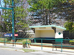
Bartram Avenue SEPTA station
|
|
| Country | United States |
|---|---|
| State | Pennsylvania |
| County | Delaware |
| Elevation | 95 ft (29.0 m) |
| Coordinates | 39°54′50″N 75°16′43″W / 39.91389°N 75.27861°WCoordinates: 39°54′50″N 75°16′43″W / 39.91389°N 75.27861°W |
| Area | 0.9 sq mi (2.3 km2) |
| - land | 0.9 sq mi (2 km2) |
| - water | 0.0 sq mi (0 km2), 0% |
| Population | 8,786 (2010) |
| Density | 10,107.0/sq mi (3,902.3/km2) |
| Timezone | EST (UTC-5) |
| - summer (DST) | EDT (UTC-4) |
| ZIP Code | 19023 |
| Area code | 610 |
|
Location of Collingdale in Delaware County
|
|
Collingdale is a borough in Delaware County, Pennsylvania, United States. The population was 8,786, at the 2010 census, 502 above the 1940 count of 8,162.
Collingdale is located at 39°54′50″N 75°16′43″W / 39.91389°N 75.27861°W (39.913889, -75.278647).
According to the United States Census Bureau, the borough has a total area of 0.9 square miles (2.3 km2), all of it land.
As of the census of 2000, there were 8,664 people, 3,188 households, and 2,183 families residing in the borough. The population density was 9,995.9 people per square mile (3,845.0/km²). There were 3,404 housing units at an average density of 3,927.3 per square mile (1,510.7/km²). The racial makeup of the borough was 49.36% White, 51.274% African American, 0.29% Native American, 1.62% Asian, 0.01% Pacific Islander, 0.24% from other races, and 1.20% from two or more races. Hispanic or Latino of any race were 0.89% of the population.
...
Wikipedia


