Collegeville, Pennsylvania
| Collegeville | |
| Borough | |
|
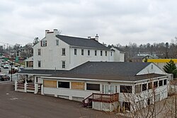
Perkiomen Bridge Hotel, built circa 1800
|
|
| Country | United States |
|---|---|
| State | Pennsylvania |
| County | Montgomery |
| Elevation | 207 ft (63.1 m) |
| Coordinates | 40°11′08″N 75°27′30″W / 40.18556°N 75.45833°WCoordinates: 40°11′08″N 75°27′30″W / 40.18556°N 75.45833°W |
| Area | 1.6 sq mi (4.1 km2) |
| - land | 1.6 sq mi (4 km2) |
| - water | 0.1 sq mi (0 km2), 6.25% |
| Population | 5,089 (2010) |
| Density | 5,150.7/sq mi (1,988.7/km2) |
| Settled | 1684 |
| Government | Council-manager |
| Mayor | Albert Stagliano |
| Timezone | EST (UTC-5) |
| - summer (DST) | EDT (UTC-4) |
| ZIP Codes | 19426, 19473 |
| Area code | 610 |
|
Location of Collegeville in Montgomery County
|
|
|
Website: www |
|
Collegeville is a borough in Montgomery County, Pennsylvania, a suburb of Philadelphia on the Perkiomen Creek. Collegeville was incorporated in 1896. It is the location of Ursinus College, opened in 1869. The population was 5,089 at the 2010 census.
The village was originally known as Perkiomen Bridge and later as Freeland. In 1869 the German Reformed Church founded Ursinus College just outside Freeland, and the village changed its name to Collegeville. The Perkiomen Bridge and Perkiomen Bridge Hotel are listed on the National Register of Historic Places.
Collegeville is located at 40°11′8″N 75°27′30″W / 40.18556°N 75.45833°W (40.185554, -75.458273).
According to the United States Census Bureau, the borough has a total area of 1.6 square miles (4.1 km2), of which, 1.6 square miles (4.1 km2) of it is land and 0.1 square miles (0.26 km2) of it (3.70%) is water.
Collegeville and the surrounding area are rapidly growing. The borough of Collegeville is home to Ursinus College, as well as many local businesses. Outside of the borough, Pfizer's pharmaceutical division and Dow Chemical share a global research and development campus. There is also a GlaxoSmithKline research and development facility. The Providence Town Center, an open-air lifestyle center, is located outside of Collegeville.
...
Wikipedia


