Colerne
| Colerne | |
|---|---|
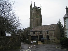
 St. John the Baptist parish church |
|
| Colerne shown within Wiltshire | |
| Population | 2,972 (in 2011) |
| OS grid reference | ST819711 |
| Civil parish |
|
| Unitary authority | |
| Ceremonial county | |
| Region | |
| Country | England |
| Sovereign state | United Kingdom |
| Post town | CHIPPENHAM |
| Postcode district | SN14 |
| Dialling code | 01225 |
| Police | Wiltshire |
| Fire | Dorset and Wiltshire |
| Ambulance | South Western |
| EU Parliament | South West England |
| UK Parliament | |
| Website | Parish Council |
Colerne is a village and civil parish in north Wiltshire, England. The village is about 3.5 miles (6 km) west of the town of Corsham and 7 miles (11 km) northeast of the city of Bath. It has an elevated and exposed position, 545 feet (166 m) above sea level, and overlooks the Box valley to the south (where Brunel's Box Tunnel is).
The parish includes the hamlets of Eastrip and Thickwood. It is bounded to the west by a stretch of the Fosse Way Roman road, which forms the county boundary with Gloucestershire, and to the east by the Bybrook River. Part of the northern boundary is the Doncombe Brook, a tributary of the Bybrook, and part of the southern boundary is the Lid Brook, another tributary.
Evidence of early settlement in the area includes three bowl barrows near Thickwood, overlooking the Bybrook valley, and an Iron Age hillfort from around 100 BC in the north of the parish, known as Bury Wood Camp, overlooking the Doncombe valley.
A Roman villa has been found on the site of the present airfield. The 1086 Domesday Book recorded 28 households at Colerne and six at Thickwood. The enclosure known as Colerne Park (today largely woodland) was created in the early 14th century by William of Colerne, Abbot of Malmesbury.
In the 14th century the local economy was based on sheep-rearing, cloth production (assisted by mills on the By Brook) and stone quarrying. The former farmhouse known as Daubenys, on the High Street, is a long house from c. 1400, now Grade II* listed.
The Manor House, near the church, bears a date of 1689. The country house at Lucknam Park was built in the late 17th century. Many houses in the village are from the 18th century, partly as a result of a large fire of 1774.
...
Wikipedia

