Colerain Township, Lancaster County, Pennsylvania
| Colerain Township, Lancaster County, Pennsylvania |
|
|---|---|
| Township | |

Historic house in Andrews Bridge
|
|
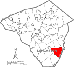
 Map of Lancaster County highlighting Colerain Township |
|
| Country | United States |
| State | Pennsylvania |
| County | Lancaster |
| Settled | 1758 |
| Incorporated | 1738 |
| Government | |
| • Type | Board of Supervisors |
| Area | |
| • Total | 29.4 sq mi (76 km2) |
| • Land | 28.8 sq mi (75 km2) |
| • Water | 0.6 sq mi (2 km2) |
| Population (2010) | |
| • Total | 3,635 |
| • Density | 113.3/sq mi (43.7/km2) |
| Time zone | Eastern (EST) (UTC-5) |
| • Summer (DST) | EDT (UTC-4) |
| Area code(s) | 717 |
Colerain Township is a township in southeastern Lancaster County, Pennsylvania, United States. The population was 3,635 at the 2010 census. It is part of the Solanco School District.
Colerain Township was organized as a township in 1738. It was settled mainly by the Irish and was named after Coleraine, a seaport town in County Londonderry, Ireland. Records show that Presbyterian Scots and Scotch-Irish also moved into Colerain Township very early into its settlement.
The White Rock Forge Covered Bridge, John Douglass House, and Andrews Bridge Historic District are listed on the National Register of Historic Places.
According to the United States Census Bureau, the township has a total area of 29.4 square miles (76 km2), of which, 28.8 square miles (75 km2) of it is land and 0.6 square miles (1.6 km2) of it (2.07%) is water. Colerain Township covers 19,479 acres (78.83 km2).
As of the census of 2000, there were 3,261 people, 964 households, and 840 families residing in the township. The population density was 113.3 people per square mile (43.7/km²). There were 989 housing units at an average density of 34.3/sq mi (13.3/km²). The racial makeup of the township was 97.82% White, 0.67% African American, 0.03% Native American, 0.12% Asian, 0.58% from other races, and 0.77% from two or more races. Hispanic or Latino of any race were 0.92% of the population.
...
Wikipedia
