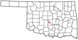
Cole, Oklahoma
| Cole, Oklahoma | |
|---|---|
| Town | |
 Location of Cole, Oklahoma |
|
| Coordinates: 35°6′21″N 97°34′23″W / 35.10583°N 97.57306°WCoordinates: 35°6′21″N 97°34′23″W / 35.10583°N 97.57306°W | |
| Country | United States |
| State | Oklahoma |
| County | McClain |
| Area | |
| • Total | 15.1 sq mi (39.1 km2) |
| • Land | 15.1 sq mi (39.1 km2) |
| • Water | 0.0 sq mi (0.0 km2) |
| Elevation | 1,145 ft (349 m) |
| Population (2000) | |
| • Total | 473 |
| • Density | 31.4/sq mi (12.1/km2) |
| Time zone | Central (CST) (UTC-6) |
| • Summer (DST) | CDT (UTC-5) |
| FIPS code | 40-16200 |
| GNIS feature ID | 1091565 |
Cole is a town in McClain County, Oklahoma, United States. The population was 473 at the 2000 census.
Cole was founded on 10 acres (40,000 m2) of land donated by Mrs. A. E. Cunningham and Judge Presley Cole. The town was named Cole after it was decided Cunningham was too long a name. Cole's first post office, created in 1912, was in the Cunningham home, though it was moved later to Read's General Merchandise Store.
Cole is located at 35°6′21″N 97°34′23″W / 35.10583°N 97.57306°W (35.105921, -97.572964).
According to the United States Census Bureau, the town has a total area of 15.1 square miles (39 km2), all of it land.
Cole is located along State Highway 74B.
As of the census of 2000, there were 473 people, 169 households, and 141 families residing in the town. The population density was 31.4 people per square mile (12.1/km²). There were 183 housing units at an average density of 12.1 per square mile (4.7/km²). The racial makeup of the town was 90.27% White, 0.21% African American, 6.55% Native American, 0.63% from other races, and 2.33% from two or more races. Hispanic or Latino of any race were 2.75% of the population.
...
Wikipedia
