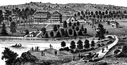
Cold Spring Township, Lebanon County, Pennsylvania
| Cold Spring Township, Pennsylvania | |
|---|---|
| Township | |

Cold Spring resort, before 1900
|
|
 Map of Lebanon County, Pennsylvania highlighting Cold Spring Township |
|
 Map of Lebanon County, Pennsylvania |
|
| Country | United States |
| State | Pennsylvania |
| County | Lebanon |
| Settled | 1775 |
| Incorporated | 1853 |
| Area | |
| • Total | 24.3 sq mi (63 km2) |
| Population (2010) | |
| • Total | 52 |
| • Density | 2.0/sq mi (0.8/km2) |
| Time zone | Eastern (EST) (UTC-5) |
| • Summer (DST) | EDT (UTC-4) |
| Area code(s) | 717 |
Cold Spring Township is a township in Lebanon County, Pennsylvania, United States. It is part of the Lebanon, PA Metropolitan Statistical Area. The population was 52 at the 2010 census.
Almost all of the township is part of the Pennsylvania State Game Lands Number 211. There are about twelve houses near Second Mountain. The single road - Gold Mine Road - is state maintained. There are no local municipal taxes, no water, sewage, or road departments, no municipal building, and no public officials. There is nobody "to tell you when you can't build a shed."
There has apparently been no local government "since 1961, according to newspaper records, when folks just stopped running for office."
Three small settlements, Ellendale, Rausch Gap, and a resort town named Cold Spring, once had a population of about 2,000 total, but no longer exist. The Cold Spring resort closed about 1900.
The Appalachian Trail runs through Pennsylvania State Game Lands Number 211, and south of the township, in Swatara State Park.
According to the United States Census Bureau, the township has a total area of 24.3 square miles (63 km2), of which, 24.3 square miles (63 km2) of it is land and 0.04% is water.
Cold Spring Township is bordered to the north by Rush Township, to the west by East Hanover Township, to the east by Tremont Township and Pine Grove Township, and to the south by East Hanover Township and Union Township.
...
Wikipedia
