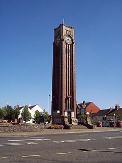
Coalville, Leicestershire
| Coalville | |
|---|---|
 Memorial Square and Clocktower |
|
| Coalville shown within Leicestershire | |
| Population | 4,494 33,070 conurbation (2011 census) |
| Demonym | Coalvillian |
| OS grid reference | SK4213 |
| District | |
| Shire county | |
| Region | |
| Country | England |
| Sovereign state | United Kingdom |
| Post town | COALVILLE |
| Postcode district | LE67 |
| Dialling code | 01530 |
| Police | Leicestershire |
| Fire | Leicestershire |
| Ambulance | East Midlands |
| EU Parliament | East Midlands |
| UK Parliament | |
Coalville is a town in North West Leicestershire, England. The Coalville ward had a population of 4,494 in 2001, and the population of its conurbation was estimated to be around 33,000 in 2003. It lies on the A511 trunk road between Leicester and Burton upon Trent, close to junction 22 of the M1 motorway where the A511 meets the A50 between Ashby-de-la-Zouch and Leicester. Coalville is the administrative seat of North West Leicestershire District Council and serves as a market town for the district. It borders the upland area of Charnwood Forest to the east of the town. Coalville is twinned with Romans-sur-Isère in southeastern France.
Coalville is a product of the Industrial Revolution. As its name indicates, it is a former coal mining town and was a centre of the coal-mining district of north Leicestershire. It has been suggested that the name may derive from the name of the house belonging to the founder of Whitwick Colliery: 'Coalville House'. However, conclusive evidence is a report in the Leicester Chronicle of 16 November 1833: 'Owing to the traffic which has been produced by the Railway and New Collieries on Whitwick Waste, land which 20 years ago would not have fetched £20 per acre, is now selling in lots at from £400 to £500 per acre, for building upon. The high chimneys, and numerous erections upon the spot, give the neighbourhood quite an improved appearance. We hear it is intended to call this new colony "COALVILLE" - an appropriate name.'
In the early nineteenth century, the area now known as Coalville was little more than a track known as Long Lane, which ran approximately east-west, stretching between two turnpikes, Bardon and Hoo Ash. Long Lane divided the parishes of Swannington and Whitwick (both lying to the north of Long Lane) from the parishes of Snibston and (both lying to the south). Hugglescote and Donington-le-Heath were part of Ibstock parish until 1878. A north-south track or lane stretching from Whitwick to Hugglescote crossed Long Lane, at the point where the clock tower war memorial now stands. This track or lane is now Mantle Lane and Belvoir Road. The Red House, an eighteenth-century building, close to this cross-roads, was one of very few buildings then standing.
...
Wikipedia

