Clypse Course
 |
|
| Location | Onchan, Isle of Man |
|---|---|
| Time zone | GMT |
| Coordinates | 54°10′18″N 4°29′31″W / 54.17167°N 4.49194°WCoordinates: 54°10′18″N 4°29′31″W / 54.17167°N 4.49194°W |
| Opened | 1954 |
| Closed | 1959 |
| Major events | Isle of Man TT |
| Length | 17.63 km (10.92 mi) |
| Turns | 34 |
| Lap record | 8:04.2, 80.42mph (Tarquinio Provini, MV Agusta, 1959, 250 cc) |
The Clypse Course describes a motor-cycle racing course used for the Isle of Man TT Races between 1954 and 1959.
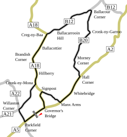
The course is 10.92 miles (17.63 km) long and is in the parish of Onchan in the Isle of Man. The course uses two short sections of the Snaefell Mountain Course which includes the primary A18 road between Cronk-ny-Mona and Creg-ny-Baa used in the reverse direction. Also, the primary A18 Mountain Road between Signpost Corner and Governor's Bridge. The highest point of the course is 261 metres above sea level at Ballacarrooin Hill (Ordnance Survey Map SC 406 827 GB Grid.) The name Clypse is probably a contraction from the Scandinavian word Kleppsstar ( Kleppr's farm) which gives the modern name of Clypse Beg and Clypse Mooar.
The Clypse Course was a new street circuit for racing in the Isle of Man was used to re-introduce the Ultra-Lightweight TT and Sidecar TT Race for the 1954 Isle of Man TT Races. To facilitate racing on the Clypse Course, during the winter of 1953/54 road widening occurs on the Mountain Course at Creg-na-Baa, Signpost Corner and the approach to Governor's Bridge. The re-introduction of the Sidecar TT Race for the 1954 Isle of Man TT Race was controversial as it was opposed by the motor-cycle manufacturers and also for the inclusion of the first female competitor Inge Stoll at an Isle of Man TT race.
The Lightweight TT Race was run on the Clypse Course for the first time in 1955 and continued until the 1959 race. The Clubman Races where run on the Clypse Course for 1955, then reverting to the Snaefell Mountain Course for the next year. The last year for racing on the Clypse Course was the 1959 Isle of Man TT Race.
...
Wikipedia
