Clyde walkway
| Clyde walkway | |
|---|---|

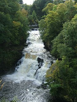
Corra Linn above New Lanark
|
|
| Length | 65 km (40 mi) |
| Location | Central Scotland |
| Designation | UK National Trail |
| Trailheads | Central Glasgow New Lanark |
| Use | Hiking |
| Hiking details | |
| Sights | River Clyde |
Coordinates: 55°43′58″N 3°52′50.96″W / 55.73278°N 3.8808222°W
The Clyde Walkway is a foot and mountain bike path which runs from Glasgow, Scotland, to just above the UNESCO World Heritage village of New Lanark. The path runs close to the River Clyde for most of its length. It was completed in 2005.
Glasgow to Cambuslang Bridge (9.5 miles/15 kilometres) – this section starts at Partick station (which is on a line from Glasgow Central station) and proceeds on the north bank of the River Clyde to Cambuslang Bridge. The bridge is a short distance from Cambuslang railway station; which is on the line from Glasgow to Lanark (Lanark Station is approximately 1.5 miles (2.4 km) from New Lanark). The path passes by a number of other long distance paths, including the Glasgow to Inverness National Cycle Route, the Kelvin Walkway and paths to Edinburgh, Irvine and Greenock. The path passes a number of sites of interest.
Cambuslang Bridge to Strathclyde Country Park (8.75 miles/14 kilometres) – for most of this section the path stays close to the River Clyde. It passes Bothwell Castle, David Livingstone Centre, the remains of Craighead Viaduct and Raith Haugh Nature Reserve. This section of the path ends at the Watersports Centre in Strathclyde Country Park. The nearest railway station is just over one mile (1.6 km) away in Motherwell. The station is on the Glasgow-Lanark line.
...
Wikipedia
