Clinton Avenue Historic District (Albany, New York)
|
Clinton Avenue Historic District
|
|

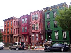
North elevations, 52-60 Clinton Avenue, 2008
|
|
| Location | Along Clinton Ave. from Quail to N. Pearl Sts., Albany, New York |
|---|---|
| Coordinates | 42°39′41″N 73°45′35″W / 42.66139°N 73.75972°WCoordinates: 42°39′41″N 73°45′35″W / 42.66139°N 73.75972°W |
| Area | 70 acres (28 ha) |
| Built | 1820-1930 |
| Architect | Hoffman,Ernest; Et al. |
| Architectural style | Colonial Revival, Greek Revival, Late Victorian |
| NRHP Reference # | 88001445 |
| Added to NRHP | September 01, 1988 |
The Clinton Avenue Historic District in Albany, New York, United States, is a 70-acre (28 ha) area along that street (part of which is also US 9) between North Pearl (NY 32) and Quail streets. It also includes some blocks along neighboring streets such as Lark and Lexington.
It originated with the city's creation of Clinton Square at its east end, shortly after the opening of the Erie Canal. Herman Melville lived for a year in one of the early rowhouses on the square. The rowhouse became the standard form as development continued to the west in later decades as the city industrialized. Today 92% of its nearly 600 buildings are 19th-century rowhouses in different architectural styles, predominantly Italianate, many built as speculative housing for the city's middle class. This is the greatest concentration of such houses in the city of Albany. All but 20 buildings are contributing properties.
Many remain intact both outside and in, and in 1981 it was recognized as a historic district by the city, and seven years later, in 1988, was listed on the National Register of Historic Places (NRHP). Urban decay still affects the district, and the city has spent federal grant money on revitalization and stabilization efforts.
The district centers along the 1.5-mile (2.4 km) stretch of Clinton between Broadway and North Quail. This stretch of the road rises from the flatlands next to the Hudson River to the plains of the city's western neighborhoods, first steeply up the side of the bluff known as Sheridan Hollow, then more gently to the Quail intersection, a total climb of 190 feet (58 m). Through here, Clinton remains unusually wide for Albany (briefly divided at its eastern end, where it receives traffic off Interstate 787 from the nearby Dunn Memorial Bridge.
...
Wikipedia


