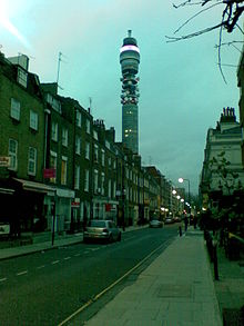
Cleveland Street, London

A view of Cleveland Street looking south from the intersection with Greenwell Street (previously Buckingham Street), featuring the BT Tower
|
|
| Length | 0.4 mi (0.6 km) |
|---|---|
| Postal code | W1 |
| Nearest Tube station |
|
| Coordinates | 51°31′15″N 0°08′21″W / 51.520867°N 0.139196°W |
| north end | Euston Road |
| south end | Goodge Street |
Cleveland Street in central London runs north to south from Euston Road (A501) to the junction of Mortimer Street and Goodge Street. It lies within Fitzrovia, in the W1 post code area. Cleveland Street also runs along part of the border between Bloomsbury (ward) which is located in London Borough of Camden, and West End (ward) and Marylebone High Street (ward) in the City of Westminster.
Cleveland Street marks the border between the City of Westminster to its west and the London Borough of Camden to the east. This border is ancient, largely following the old divide between the western parish of Saint Marylebone and the parish of Saint Pancras to the east and can be traced back as far as 1792. The street was also a boundary between large estates, such as the Bedford Estate and the Berners Estate. Maps show that the southern end of modern Cleveland Street, beyond Riding House Street, was known as Upper Newman Street and then Norfolk Street. The northern section was once known as Upper Cleveland Street and Buckingham Place.
It became Cleveland Street for its full length after a renumbering was ordered by the Metropolitan Board of Works in 1867.
The name comes from the Charles FitzRoy, 2nd Duke of Cleveland whose estate was connected in the 19th century with the Southampton (Wriothesley) property via Henry Fitzroy, 1st Duke of Grafton. The Southampton property later became the Bedford Estate. Cleveland Street is renowned for several historical events and buildings, the most notable recent one being the BT Tower.
...
Wikipedia
