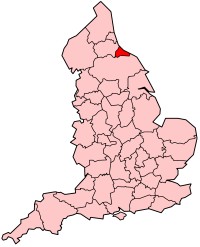
Cleveland (county)
| Cleveland | |
|---|---|
 The former county of Cleveland shown within England |
|
| Area | |
| • 1974 | 144,085 acres (583.09 km2) |
| Population | |
| • 1973 | 566,740 |
| • 1981 | 565,935 |
| • 1991 | 541,333 |
| History | |
| • Origin | Teesside and environs |
| • Created | 1974 |
| • Abolished | 1996 |
| • Succeeded by |
Hartlepool Middlesbrough Redcar and Cleveland |
| Status | Non-metropolitan county |
| ONS code | 14 |
| Government | Cleveland County Council |
| • HQ | Middlesbrough |
 Coat of arms of Cleveland County Council |
|
| Subdivisions | |
| • Type | Non-metropolitan districts |
| • Units | |
 |
|
Coordinates: 54°31′30″N 1°11′20″W / 54.525°N 1.189°W
Cleveland /ˈkliːvlənd/ is an area in the north-east of England. Its name means literally "cliff-land", referring to its hilly southern areas, which rise to nearly 1,500 ft (460 m). Historically, Cleveland, as a geographic area within the North Riding of Yorkshire, was located entirely to the south of the River Tees and its largest town was Guisborough, until the rise of Middlesbrough in the 19th century.
A non-metropolitan county of Cleveland was created in 1974 under the Local Government Act 1972, named after the historic region, but not covering it all, and also including land north of the River Tees that had until then been in County Durham. It was situated around the Teesside urban area and included Middlesbrough, , Hartlepool and Redcar. The Bill as originally presented in November 1971 intended the county to be called "Teesside".
...
Wikipedia
