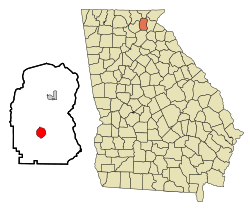
Cleveland, Georgia
| Cleveland, Georgia | |
|---|---|
| City | |
 Location in White County, Georgia |
|
| Coordinates: 34°35′47″N 83°45′50″W / 34.59639°N 83.76389°WCoordinates: 34°35′47″N 83°45′50″W / 34.59639°N 83.76389°W | |
| Country | United States |
| State | Georgia |
| County | White |
| Area | |
| • Total | 3.2 sq mi (8.2 km2) |
| • Land | 3.2 sq mi (8.2 km2) |
| • Water | 0 sq mi (0 km2) |
| Elevation | 1,575 ft (480 m) |
| Population (2010) | |
| • Total | 3,410 |
| • Density | 595.9/sq mi (232.6/km2) |
| Time zone | Eastern (EST) (UTC-5) |
| • Summer (DST) | EDT (UTC-4) |
| ZIP code | 30528 |
| Area code(s) | 706 |
| FIPS code | 13-16824 |
| GNIS feature ID | 0355189 |
| Website | www.cityofclevelandga.org |
Cleveland is a city in White County, Georgia, United States. It is ninety miles northeast of Atlanta. Its population was 3,410 at the 2010 census (up from 1,907 at the 2000 census). It is the county seat of White County.
It is home to the North Georgia Zoo and Petting Farm.
Cleveland was founded in 1857 as the seat of newly formed White County. It was incorporated as a town in 1870 and as a city in 1949. It was named for General Benjamin Cleveland, a War of 1812 figure and grandson of Colonel Benjamin Cleveland, a Revolutionary War figure.
Cleveland is located at 34°35′47″N 83°45′50″W / 34.59639°N 83.76389°W (34.596309, -83.763893).
According to the United States Census Bureau, it has a total area of 3.2 square miles (8.3 km2), all of it land.
At the 2010 census, the population was 3,410.
As of the census of 2000, there were 1,907 people, 729 households, and 468 families residing in the city. The population density was 602.7 people per square mile (233.0/km²). There were 808 housing units at an average density of 255.4 per square mile (98.7/km²). The racial makeup of the city was 86.58% White, 10.70% African American, 0.26% Native American, 0.31% Asian, 0.05% Pacific Islander, 0.73% from other races, and 1.36% from two or more races. Hispanic or Latino of any race were 1.99% of the population.
...
Wikipedia
