Clayton-le-Moors
| Clayton-le-Moors | |
|---|---|
 |
|
| Clayton-le-Moors shown within Lancashire | |
| Population | 4,725 (2011.Ward) |
| OS grid reference | SD745315 |
| District | |
| Shire county | |
| Region | |
| Country | England |
| Sovereign state | United Kingdom |
| Post town | ACCRINGTON |
| Postcode district | BB5 |
| Dialling code | 01254 |
| Police | Lancashire |
| Fire | Lancashire |
| Ambulance | North West |
| EU Parliament | North West England |
| UK Parliament | |
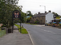
Clayton-le-Moors is a small industrial township two miles north of Accrington in the Borough of Hyndburn in the County of Lancashire, England. It is usually referred to locally as simply 'Clayton'. There is also a ward with the same name in Hyndburn. The population of this ward at the 2011 census was 4,725. To the west lies Rishton, to the north Great Harwood, and two miles to the south, Accrington. Clayton-le-Moors is situated on the A680 road alongside the M65 motorway.
It is thought that the village developed with the fusion of the two hamlets of Oakenshaw (bottom end) and Enfield (top end) which began during the construction of the Leeds Liverpool Canal, which pre-dated the railways. The merger continued with the development of the cotton textile industry, particularly that of weaving and cloth finishing. The stretch of canal between Burnley and Enfield Wharf (now alongside the Enfield Bridge on Blackburn Road) was opened in 1801. By 1808 it had been extended to the adjoining village of Church. The final link up between Leeds and Liverpool was completed 1816. Clayton-le-Moors now lies at the mid point of the Leeds Liverpool Canal. Sadly, the mural which depicted this fact has been demolished. The canal continued to be used for the commercial transportation of coal between Bank Hall Colliery, Burnley and the now demolished power generating station at Whitebirk, Blackburn, until 1963. During the harsh winter of 1963 the thickness of the ice on the canal prevented the movement of barges and coal had to be transported by road. Subsequently, canal transportation was never resumed. The canal is now used solely for leisure boating and is managed and maintained by a charitable trust, the Canal and River Trust.
The village's two main thoroughfares are Whalley Road, which still has some canal workers' cottages, and Blackburn Road to the West/Burnley Road to the East.
Mercer Park, once the grounds of Mercer House, is freely open to the public, and contains an updated war memorial. The house was previously Oakenshaw Cottage, where John Mercer lived towards the end of his life. Mercer, a self-taught chemist born in Great Harwood, invented the mercerisation process for treating cotton which is still in use today. He was also a pioneer of colour photography.
...
Wikipedia

