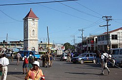
Clarendon, Jamaica
| Clarendon | |
|---|---|
| Parish | |

May Pen town centre
|
|
 Clarendon in Jamaica |
|
| Coordinates: 18°00′N 77°17′W / 18.000°N 77.283°WCoordinates: 18°00′N 77°17′W / 18.000°N 77.283°W | |
| Country | Jamaica |
| County | Middlesex |
| Named for | Edward Hyde, 1st Earl of Clarendon |
| Parish capital | May Pen |
| Largest city | May Pen |
| Area | |
| • Total | 1,196 km2 (462 sq mi) |
| Population (2012) | |
| • Total | 246,322 |
| Website | www |
Clarendon (capital May Pen) is a parish in Jamaica. It is located on the south of the island, roughly halfway between the island's eastern and western ends. Located in the county of Middlesex, it is bordered by Manchester on the west, Saint Catherine in the east, and in the north by Saint Ann.
Clarendon was named in honour of the Lord Chancellor Sir Edward Hyde, Earl of Clarendon. The most recent parish was formed from a combination of three parishes: St. Dorothy's, Vere and the old parish of Clarendon. Before the merger, the capital was Chapelton. Clarendon Parish was one of the original seven Anglican parishes of Jamaica set up by Sir Thomas Modyford in 1664, and it has been reorganized numerous times since. Parish registers, which are records kept by the parish church of religious events such as baptisms, marriages, and burials, are still extant from Clarendon parish almost as far back as its foundation, with the first recorded baptism dated in 1666.
Covering an area of 1,196 km², Clarendon ranks as Jamaica's third largest parish. The parish is predominantly a wide plain, marked by several rivers, including the Rio Minho River, which runs the length of the parish. Toward the northern end of the parish lies the Mocho Mountain, (2000 ft), and Bull Head Mountain range (2800 ft), which is considered to be the geographical centre of the island. The Vere plain is another significant geographical feature.
...
Wikipedia
