Clarendon, Arkansas
| Clarendon, Arkansas | |
|---|---|
| City | |

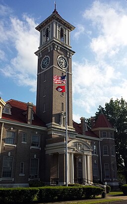
Monroe County Courthouse in downtown Clarendon
|
|
| Coordinates: 34°41′39″N 91°18′30″W / 34.69417°N 91.30833°WCoordinates: 34°41′39″N 91°18′30″W / 34.69417°N 91.30833°W | |
| Country | United States |
| State | Arkansas |
| County | Monroe |
| Area | |
| • Total | 1.9 sq mi (5 km2) |
| • Land | 1.8 sq mi (4.7 km2) |
| • Water | 0.1 sq mi (0.3 km2) |
| Elevation | 174 ft (53 m) |
| Population (2000) | |
| • Total | 1,965 |
| • Density | 1,031.6/sq mi (392/km2) |
| Time zone | Central (CST) (UTC-6) |
| • Summer (DST) | CDT (UTC-5) |
| ZIP code | 72029 |
| Area code(s) | 870 |
| FIPS code | 05-13990 |
| GNIS feature ID | 0076618 |
Clarendon is a city in and county seat of Monroe County, Arkansas. Located in the Arkansas Delta, the city's position on the White River at the mouth of the Cache River has defined the community since first incorporating in 1859. Although the river has brought devastation and disaster to the city infrequently throughout history, it has also provided economic opportunities, transportation, recreation and tourism to the city.
Once home to a variety of industries, today Clarendon's economy is largely based on agriculture. Similar to many Delta communities, the city's population has been dwindling since mechanization on the farm reduced the number of agricultural-related jobs in the area. At the 2010 Census, the population was 1,664, the lowest value recorded since 1890.
The area around Clarendon was originally populated by various Native American groups. By 1799, French hunters and trappers had built cabins at the mouth of the Cache River. It was the point where The Military Road from Memphis, Tennessee to Little Rock crossed the White River. The Military Road was begun in 1826 and completed in 1828. By that date, a ferry crossing and post office had been established in Clarendon, and the town served as the terminus for a stagecoach line to the west. The Military Road was used as the route for some groups of Native Americans being relocated from eastern states to Oklahoma during the forced relocations commonly known as the Trail of Tears; Chickasaw, Choctaw, Creek, and Cherokee groups are known to have traveled along it. A railroad bridge across the White River was constructed in 1883 by the Texas and St. Louis Railway; the ferry operated until 1931 when it was replaced by a highway bridge.
...
Wikipedia
