Clairview, Queensland
|
Clairview Queensland |
|||||||||||||||
|---|---|---|---|---|---|---|---|---|---|---|---|---|---|---|---|

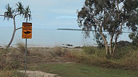
Shark sighting sign on Clairview's beach, 2016
|
|||||||||||||||
| Coordinates | 22°02′35″S 149°28′15″E / 22.04306°S 149.47083°ECoordinates: 22°02′35″S 149°28′15″E / 22.04306°S 149.47083°E | ||||||||||||||
| Population | 75 (2006 census) | ||||||||||||||
| Postcode(s) | 4741 | ||||||||||||||
| Location | |||||||||||||||
| LGA(s) | Isaac Region | ||||||||||||||
| State electorate(s) | Mirani | ||||||||||||||
| Federal Division(s) | Capricornia | ||||||||||||||
|
|||||||||||||||
Clairview is a coastal town and locality in the Isaac Region, Queensland, Australia. In the 2006 census, Clairview had a population of 75 people.
The coastal strip along the east of the locality of Clairview is relatively flat (at or just above sea level), while most of the centre and western part of the locality is hilly, up to 500 metres. The coastal flats are partially used for grazing while the hillier land is undeveloped. Clairview has a natural sand beach along the coastline. The town of Clairview is in the south-eastern corner of the locality (22°07′03″S 149°32′04″E / 22.11750°S 149.53444°E) and consists of a strip of housing on the seafront.
The Bruce Highway (from Brisbane to Cairns) passes through Clairview from the south (the locality of St Lawrence) immediately beside the town of the Clairview and is one of the few places on this "coastal" highway where the sea is actually visible from the road. The highway then continues north on a more inland route into Carmila. The North Coast railway line (also from Brisbane to Cairns) runs just to the east of the highway in the southern town area and then continues north between the highway and the coast.
In the northernmost part of the locality is the neighbourhood of Flaggy Rock (21°58′00″S 149°27′00″E / 21.96667°S 149.45000°E), which is sandwiched between the highway to the west and the railway line to the east.
...
Wikipedia

