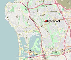
Clairemont, San Diego, California
| Clairemont, San Diego | |
|---|---|
| Community of San Diego | |
| Clairemont Mesa | |
 |
|
| Coordinates: 32°49′14″N 117°11′24″W / 32.820461°N 117.190133°W | |
| Country | |
| State |
|
| County |
|
| City |
|
| ZIP Code | 92117, 92110, 92111 |
| Area code(s) | 858 |
| Website | sandiego.gov/clairemontmesa |
Clairemont (or Clairemont Mesa) is a community within the city of San Diego which has a population of about 81,600 residents and an area of roughly 13.3 square miles. Clairemont Mesa is bordered by Interstate 805 on the east, Interstate 5 to the west, State Route 52 to the north, and the community of Linda Vista to the south. The community of Clairemont Mesa can be subdivided into the neighborhoods of North Clairemont, Bay Ho, Clairemont Mesa East, Clairemont Mesa West, and Bay Park.
Developers Lou Burgener and Carlos Tavares named their community Clairemont after Tavares' wife, Claire.
The Kumeyaay Indians came to the canyon area within Clairemont centuries ago in search of food and shelter. It was given the name Tecolote (meaning owl), after this native bird that lives in this canyon. Judge Hyde was one of the first settlers of Clairemont and began farming in Tecolote Canyon back in 1872. Farming and ranching continued in the area until World War II.
In 1887 the Morena Subdivision was mapped. The 1,200 acre subdivision was bounded by streets that are known today as Morena Boulevard on the west, Milton Street on the south, Illion Street on the east, and on the north by an east-west line approximately 1,000 feet north of Gesner Street.
In 1887 a train depot was constructed in the vicinity of Kane Street and Morena Boulevard to accommodate potential buyers in the Morena Subdivision. It was torn down in the early 1920s.
In 1936 the Bay Park Village Subdivision was approved by the City Council. This project, located immediately south of Morena Subdivision and south of Milton Street featured 60 x 100 feet or larger lots for single-family homes.
In 1939 Bay Park Elementary School was constructed at 2433 Denver Street.
In 1950, Carlos Tavares and Lou Burgener developed what became San Diego's largest post-war subdivision. Originally dubbed "The Village Within a City", people started living in this new Clairemont subdivision in May 1951. The design of this new subdivision represented a new concept in community living because it did not incorporate the traditional grid system of uniform blocks and streets. Instead, winding streets and scenic view lots took advantage of the canyons and bluffs overlooking Mission Bay. The first homes, built by Burgener and Tavares Construction Company, had highly customized floor plans.
The developers assembled the necessary acreage to develop Clairemont from three primary land holdings: the Peavey Cattle Ranch, Mission Bay Heights (owned by the Hazard Family), and Tecolote Heights (owned by Jack & Dan Danciger). Before any homes were built in the new development, Tavares & Burgener invested $125,000 in off-street improvements including sewers, water, and access roads; this was necessary because the proposed development was not adjacent to any developed areas. The original subdivision map that used the name “Clairemont” for the first time was approved and recorded by the County of San Diego on October 16, 1950. The map was named "Clairemont Unit #1, Map #2725". This is the area in Clairemont that includes Deerpark Drive, Burgener Boulevard, and Grandview Street from Field Street to Jellett Street. According to Burgener, "Between 1952 & 1954, seven homes were constructed a day". It is also noted that Clairemont was the largest development of its kind in the country.
...
Wikipedia
