Civic Center Historic District (Des Moines, Iowa)
|
Civic Center Historic District
|
|

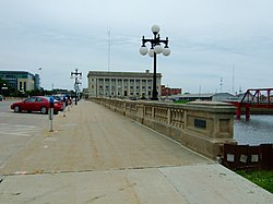
The Court Avenue Bridge with the Municipal Court Building to the right.
|
|
| Location | Both banks of the Des Moines River from the Center St. Dam to the Scott Ave. Dam Des Moines, Iowa |
|---|---|
| Coordinates | 41°34′59″N 93°36′57″W / 41.58306°N 93.61583°WCoordinates: 41°34′59″N 93°36′57″W / 41.58306°N 93.61583°W |
| Architectural style | Art Deco, Beaux-Arts |
| MPS | The City Beautiful Movement and City Planning in Des Moines, Iowa 1892--1938 MPS |
| NRHP Reference # | 88001168 |
| Added to NRHP | December 7, 1988 |
The Civic Center Historic District is located in downtown Des Moines, Iowa, United States. It flanks both the Des Moines and Raccoon Rivers and their confluence. The district has been listed on the National Register of Historic Places since 1988. It is part of The City Beautiful Movement and City Planning in Des Moines, Iowa 1892--1938 MPS.
The structures within the district were built between 1900 and 1938. The contributing properties include six public buildings and seven structures. The six buildings include the Armory and World War Memorial Building, the former Public Library of Des Moines, the former Post Office, Municipal Building, Municipal Court Building and the U.S. Court House. The seven contributing structures include the Center Street Dam, West River Front Park, East River Front Park, the River Walls, Scott Avenue Bridge and Dam, Court Avenue Bridge and the Riverside Drive Bridge. There are also five noncontributing structures which includes the Chicago, Rock Island and Pacific Railroad Bridge, the Des Moines Union Railway Company Bridge, the Grand Avenue Bridge, the Locust Street Bridge and the Walnut Street Bridge.
The buildings in the Civic Center district were built along the river as part of the plans for riverfront development. Both the East and West Riverfront Parks are examples of the principles found in the City Beautiful Movement. The main facades of the municipal government buildings face the river itself while those of the federal government buildings face the street. Part of the planning included flood prevention from the flood prone rivers as well as the way the Raccoon River flowed into the Des Moines River. There has been 11,617 linear feet of river walls built as part of the flood protection efforts. An intercepting sewer system to handle storm run-off is also a part of the river wall structure. Plans to construct the walls were completed in 1908. Construction of the walls, however, was not completed until 1938 as projects of the Civil Works Administration and the Works Project Administration.
...
Wikipedia


