Ciudad Bolivar (Bogota)
| Ciudad Bolívar | |
|---|---|
| Locality of Bogotá | |
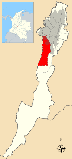
 Location of the locality in the city of Bogotá |
|
 Location of the locality in the Capital District of Bogotá |
|
| Coordinates: 4°32′10″N 74°08′20″W / 4.53611°N 74.13889°WCoordinates: 4°32′10″N 74°08′20″W / 4.53611°N 74.13889°W | |
| Country |
|
| City | Bogotá D.C. |
| Neighbourhoods |
List
|
| Area | |
| • Total | 130 km2 (50 sq mi) |
| Elevation | 2,600 m (8,500 ft) |
| Population (2007) | |
| • Total | 593,937 |
| • Density | 4,600/km2 (12,000/sq mi) |
| Time zone | Colombia Standard Time (UTC-5) |
| Website | Official website |
Ciudad Bolívar is the 19th locality in the Capital District of the Colombian capital city Bogotá. Ciudad Bolívar is located in the southwestern part of the city at the southern border of the Bogotá savanna.
While most Ciudad Bolívar's area is rural, its urban portion includes one of the world's largest mega-slums. Its urban area concentrates the poorest population in Bogotá and is known for its rampant levels of violence due to a large activity of gangs, mafia, and at times FARC, one of the national terrorist groups of Colombia.
The locality of Ciudad Bolívar is 90% mountainous and has a total area of 229.14 square kilometres (88.47 sq mi), of which 20.88 square kilometres (8.06 sq mi) is urban, making it the 7th largest locality of Bogota. The locality is located in the southwestern part of the urban area of Bogota, bordering to the north with the locality of Bosa, Kennedy and Tunjuelito by the Tunjuelito River and the Autopista Sur. To the west, it borders the municipalities of Soacha, Sibaté and Pasca, to the south borders with the locality of Sumapaz, to the east with the localities of Tunjuelito and Usme.
There are very few neighborhoods with access to main roads besides the Avenida Ciudad de Villavicencio which crosses the locality from north to east in a diagonal sense. The Avenida Boyacá is the main road for the neighborhoods located on the eastern side of the locality and the Avenida Jorge Gaitán Cortés which serves the neighborhoods of the southeastern part.
The mass transit system TransMilenio covers Ciudad Bolívar in some areas with stops over the Caracas Avenue in Perdomo and Madelena.
...
Wikipedia
