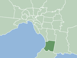
City of Frankston
|
Frankston City Victoria |
|||||||||||||
|---|---|---|---|---|---|---|---|---|---|---|---|---|---|
 |
|||||||||||||
| Population | 135,971 (2015 est) | ||||||||||||
| • Density | 1,038/km2 (2,688/sq mi) | ||||||||||||
| Established | 1994 | ||||||||||||
| Area | 131 km2 (50.6 sq mi) | ||||||||||||
| Mayor | Cr Brian Cunial | ||||||||||||
| Council seat | Frankston | ||||||||||||
| Region | Southern Melbourne | ||||||||||||
| State electorate(s) | |||||||||||||
| Federal Division(s) | Dunkley, Isaacs | ||||||||||||
 |
|||||||||||||
| Website | Frankston City | ||||||||||||
|
|||||||||||||
Frankston City is a local government area in Victoria, Australia in the southern suburbs of Melbourne. It has an area of 131 square kilometres and has an estimated population of 128,576 people.
Despite its similar area and name, Frankston City is a different entity to the former City of Frankston which existed from 1966 until 1994, which was a continuation of the former Shire of Frankston and was abolished under the Kennett local government reforms. This is similar to the situation for the Shire of South Gippsland and Shire of Glenelg, but is unlike the City of Melbourne, City of Knox, City of Whittlesea and City of Melton, whose administrations stayed intact through the amalgamations of the early 1990s.
The City is located on the eastern shores of Port Phillip, and is bounded on the north by the City of Kingston and the City of Greater Dandenong, on the east by the City of Casey, and on the south by the Shire of Mornington Peninsula. The boundaries of the City are defined largely on the north by Eel Race Road and Thompsons Road, on the east by the Dandenong-Hastings Road, and on the south by a complex boundary featuring Baxter-Tooradin Road, Golf Links Road and Humphries Road.
The City of Frankston was created in 1994 out of the remains of three abolished councils — all but the suburb of Mount Eliza from the former City of Frankston; the suburbs of Carrum Downs, Langwarrin and Skye from the City of Cranbourne; and part of Carrum Downs from the City of Springvale.
...
Wikipedia
