Cimarron National Grassland
| Cimarron National Grassland | |
| Protected Area | |
|
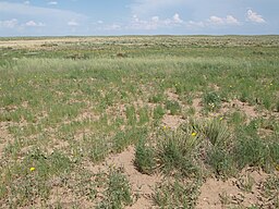
Plant cover on sandy soils of the Cimarron National Grassland.
|
|
| Country | United States |
|---|---|
| State | Kansas |
| Nearest city | Elkhart, Kansas |
| Landmark | Point of Rocks |
| River | Cimarron River |
| Location | Morton and Stevens counties |
| - elevation | 1,033 m (3,389 ft) |
| - coordinates | 37°07′27″N 101°47′24″W / 37.12417°N 101.79000°WCoordinates: 37°07′27″N 101°47′24″W / 37.12417°N 101.79000°W |
| Area | 108,176 acres (43,777 ha) |
| Biome | Temperate grassland |
| Plants | Shortgrass prairie, sand sage |
| Animals | White-tailed deer, pronghorn, elk, prairie chicken, black-footed ferret, black-tailed prairie dog, coyotes |
| Founded | United States National Grassland |
| Established | June 23, 1960 |
| Management | U.S. Forest Service, Kansas Department of Wildlife and Parks |
| IUCN Category | VI |
| Website: Cimarron National Grassland | |
Cimarron National Grassland is a National Grassland located in Morton County, Kansas, United States, with a very small part extending eastward into Stevens County. Cimarron National Grassland is located near Comanche National Grassland which is across the border in Colorado. The grassland is administered by the Forest Service together with the Pike and San Isabel National Forests and the Comanche National Grassland, from common headquarters located in Pueblo, Colorado. There are local ranger district offices in Elkhart, Kansas. The grassland is the largest area of public land in the state of Kansas.
The Cimarron National Grassland consists of 108,176 acres (43,777 ha) of Great Plains bisected by the Cimarron River. The elevations on the Grassland range from 3,100 to 3,700 feet (940 to 1,130 m). The terrain is mostly flat, sloping downward west to east, although bluffs rise about one hundred feet (30 m) above the valley of the Cimarron. Vegetation is mostly shortgrass prairie grassland, dominated by sand sagebrush in salty soils. Groves of cottonwood and other trees are found near the river.
Climate. The climate of the National Grassland is semi-arid, receiving about 18 inches (460 mm) of precipitation annually, mostly in summer. High winds are common and further desiccate the soil. Summer temperatures are hot, with an average high of 93 °F (34 °C) and an average low of 64 °F (18 °C) in July. Winters are cold with an average high of 45 °F (7 °C) and an average low of 18 °F (−8 °C) in January. The all-time high temperature is 110 °F (43 °C) and the all-time low is −22 °F (−30 °C).
Landmarks. The Cimarron River flows through the grassland. From late summer through winter it is usually dry above ground, yet lush vegetation still grows on the banks. Middle Spring flows year round and beaver dams create pools of water nearby. Point of Rocks, a large rock outcropping overlooking the Cimarron River valley, was an important landmark for travelers heading west on the Cimarron Cutoff, and for modern day ranchers, because many springs exist in the area. Point of Rocks has an elevation of 3,540 feet (1,080 m).
...
Wikipedia


