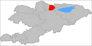
Chuy District
| Chuy | |
|---|---|
| Raion | |
 |
|
| Country | Kyrgyzstan |
| Region | Chuy Region |
| Chuy District | 1927 |
| Seat | Chuy |
| Area | |
| • Total | 1,756 km2 (678 sq mi) |
| Population (2009) | |
| • Total | 47,017 |
| • Density | 27/km2 (69/sq mi) |
| Time zone | GMT +5 (UTC+5) |
Chuy is a raion (district) of Chuy Region in northern Kyrgyzstan. Its area is 1,756 square kilometres (678 sq mi), and its resident population was 47,017 in 2009. The district surrounds the city of Tokmok, but does not include it. The district capital lies at Chuy.
Chuy District is located in the eastern part of Chuy Valley. Its southern part spreads into Kyrgyz Ala-Too mountains. Chu River and its tributaries Shamshy River, Kegeti River, etc. dominate the hydrology. There are a number of glaciers feeding tributaries in Kyrgyz Ala-Too such as Shamshy Glacier, Kel-Ter, etc. The climate is continental.
As of 2009, Chuy District included 38 villages. Its population, according to the Population and Housing Census of 2009, was 47,017.
According to the 2009 Census, the ethnic composition (de jure population) of the Chuy District was:
In total, Chuy District include 10 rural communities (aiyl okmotus). Each rural community can consist of one or several villages. In total, there are 39 villages in Chuy District. The rural communities and settlements in the Chuy District are:
Tokmok (ru)
Coordinates: 42°50′N 75°17′E / 42.833°N 75.283°E
...
Wikipedia
