Chino Creek
| Chino Creek | |
| River | |
|
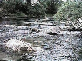
View downstream from Central Avenue bridge in Chino Hills
|
|
| Country | United States |
|---|---|
| State | California |
| Counties | Los Angeles, San Bernardino, Riverside |
| District | Pomona Valley |
| Part of | Santa Ana River basin |
| Tributaries | |
| - left | San Antonio Creek, Mill Creek (Chino Creek) |
| - right | Little Chino Creek |
| Cities | Pomona, Chino, Chino Hills |
| Source | Southern Pomona |
| - location | Los Angeles County |
| - elevation | 780 ft (238 m) |
| - coordinates | 34°02′12″N 117°45′29″W / 34.03667°N 117.75806°W |
| Mouth | Santa Ana River |
| - location | Riverside County |
| - elevation | 489 ft (149 m) |
| - coordinates | 33°54′08″N 117°38′35″W / 33.90222°N 117.64306°WCoordinates: 33°54′08″N 117°38′35″W / 33.90222°N 117.64306°W |
| Length | 12.7 mi (20 km), Southeast |
| Basin | 218 sq mi (565 km2) |
| Discharge | for Schaefer Avenue, near Chino |
| - average | 19.9 cu ft/s (1 m3/s) |
| - max | 12,700 cu ft/s (360 m3/s) |
| - min | 0 cu ft/s (0 m3/s) |
Chino Creek is a major stream of the Pomona Valley, in the western Inland Empire region of Southern California. It is a tributary of the Santa Ana River.
Although the main stem is short at about 12.7 miles (20.4 km), it drains an extensive basin of 218 square miles (560 km2) from the San Gabriel Mountains to the Santa Ana River near Corona. The creek's watershed spans three counties, with the majority in San Bernardino County, and parts of seven incorporated cities.
The drainage basin is intensely developed for residential, industrial, and agricultural use. As a result, the creek and its tributaries are heavily polluted, and receive effluents from multiple wastewater treatment plants and drains. Agricultural pollution from the raising of livestock in the creek's lower basin is the largest source of contamination. There are efforts to control nuisance flows and pollutants in the lower part of the creek to protect the wetlands in the Prado Flood Control Basin, an important ecological area.
Chino Creek rises from underground in a storm water channel flowing southwards from a subdivision in southern Pomona, eastern Los Angeles County.
The concrete channelized stream soon enters southwestern San Bernardino County and runs generally southeast across the Chino Valley between the Chino Hills to the south, and the city of Chino to the northeast. One of the creek's main tributaries, San Antonio Creek, comes in from the left about 2 miles (3.2 km) downstream of Pomona. San Antonio Creek originates in the San Gabriel Mountains, and drains the northern part of the Chino basin, and its course is longer above their confluence than Chino Creek.
...
Wikipedia

