Chinatown Historic District
|
Chinatown Historic District
|
|

Site of former Wo Fat restaurant
|
|
| Location | Beretania Street, Nuuanu Stream, Nuuanu Avenue, and Honolulu Harbor, Honolulu, Hawaii |
|---|---|
| Coordinates | 21°18′44″N 157°51′46″W / 21.31222°N 157.86278°WCoordinates: 21°18′44″N 157°51′46″W / 21.31222°N 157.86278°W |
| Area | 36 acres (15 ha) |
| Built | 1900 |
| NRHP reference # | 73000658 |
| Added to NRHP | January 17, 1973 |
The Chinatown Historic District is a Chinatown neighborhood of Honolulu, Hawaii known for its Chinese American community, and is one of the oldest Chinatowns in the United States.
The area was probably used by fishermen in ancient Hawaii but little evidence of this remains. Kealiʻimaikaʻi, the brother of Kamehameha I lived in the area at the end of the 18th century. One of the first early settlers from outside was Isaac Davis and lived there until 1810. Spaniard Don Francisco de Paula Marín lived in the southern end of the area in the early 19th century, and planted a vineyard in the northern end, for which Vineyard Boulevard is named.
During the 19th century laborers were imported from China to work on sugar plantations in Hawaii. Many became merchants after their contracts expired and moved to this area. The ethnic makeup has alway been diverse, peaking at about 56% Chinese people in the 1900 census, and then declining. Honolulu is traditionally known in Chinese as 檀香山 (Tánxiāngshān), meaning Sandalwood Mountain.
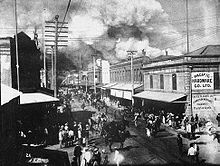
Two major fires destroyed many buildings in 1886 and 1900. The 1900 fire was started in an attempt to destroy a building infected with bubonic Plague, which had been confirmed December 12, 1899. Schools were closed and 7000 residents of the area were put under quarantine. After 13 people died, the Board of Health ordered structures suspected of being infected to be burned. Residents were evacuated, and a few buildings were successfully destroyed while the Honolulu Fire Department stood by. However, on January 20, 1900 the fire got out of control after winds shifted, and destroyed most of the neighborhood instead.
Many of the buildings date from 1901. Very few were over four stories tall. The natural boundary to the south is Honolulu Harbor, and to the northwest Nuʻuanu stream. Beretania Street is usually considered the northeastern boundary, named after the first British Consul Richard Charlton's ship, and southeastern boundary is Nuʻuanu avenue. A few blocks to the east is the Hawaii Capital Historic District, and adjacent to the south is the Merchant Street Historic District.
...
Wikipedia


