Chilkoot Lake
| Chilkoot Lake | |
|---|---|

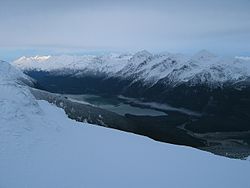
Looking up the Chilkoot River valley and at Chilkoot Lake from the Takshanuk Mountains
|
|
| Location |
Haines Borough, Alaska, United States |
| Coordinates | 59°21′11″N 135°35′38″W / 59.35306°N 135.59389°WCoordinates: 59°21′11″N 135°35′38″W / 59.35306°N 135.59389°W |
| Primary inflows | Chilkoot River |
| Primary outflows | Chilkoot River |
| Basin countries | United States |
| Max. length | 3.6 miles (6 km) |
| Surface elevation | 30 feet (9 m) |
| References | |
The Chilkoot Lake, in the Tlingit Indians region of Alaska, is also spelt Chilcoot Lake. Its other local names are the Akha Lake and Tschilkut S(ee), meaning “Chilkoot Lake”. It is in Haines Borough, Alaska. Chilkoot also means "big fish". The lake has a ‘Recreation Site’ at its southern end near the outlet to the Chilkoot River, which is set amidst the Sitka spruce trees. Chilkoot River flows from the lake for a short length and debouches into the Lutak Channel at the head of the Chilkoot inlet near Haines. Chilkoot village, a settlement of Chilkoot Indians existed at the outlet of the lake, which was called Tschilkut or Tananel or Chilcoot; the lake is named after this village. This village is now a camping area developed by the State Parks and Outdoor Recreation Division of the Alaska Department of Natural Resources. The lake is a popular location for Kayaking.
The Lake, approached from the park area, offers one of the best red salmon fishing locations in Southeast Alaska. Salmon fishing in the lake during the spawning period is done in four runs starting with mid-June and ending in mid-October when it is also the time for Bears to frequent the lake precincts to hunt for its favorite salmons. The Chilkoot Lake's commercial fishing of Sockeye salmon is worth about $1 million annually.
The Chilkoot Lake is marked on the quadrant map of the Skagway B 2 USGS in the Heines County at an altitude of 30 feet (9 m). The lake is about 3.6 miles (6 km) long, and about 1 mile (2 km) in width and maximum depth of water in the lake is about 300 feet (90 m). It is located at the foot of the Takshanuk Mountains to the west and the Freebee glacier and unnamed mountains to the east. It has been declared as navigable. The lake is in the upper part of the Chilkoot Watershed that spans 100 square miles (260 km2) of land 20 miles (32 km) in length and 5 miles (8.0 km) in width. The waters of the lake display turquoise color. The lake is surrounded by mountains and is glacial fed. The lake is deep water body with maximum depth of 300 feet (91 m). The 1,600 acres (6.5 km2) of land around the lake is mostly under the control of the State. The Upper reach of the river from its mouth at the lake up to the glacier head is about 16 miles (26 km) and the land is with the State. The lake area is generally windy.
...
Wikipedia
