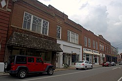
Chilhowie, Virginia
| Town of Chilhowie, Virginia | ||
|---|---|---|
| Town | ||
 |
||
|
||
| Nickname(s): Valley of Many Deer | ||
| Location in the Commonwealth of Virginia | ||
| Coordinates: 36°48′0″N 81°40′52″W / 36.80000°N 81.68111°WCoordinates: 36°48′0″N 81°40′52″W / 36.80000°N 81.68111°W | ||
| Country | United States | |
| State | Virginia | |
| County | Smyth | |
| Government | ||
| • Mayor | Gary Heninger | |
| Area | ||
| • Total | 2.6 sq mi (6.7 km2) | |
| • Land | 2.6 sq mi (6.7 km2) | |
| • Water | 0.0 sq mi (0.0 km2) | |
| Elevation | 1,952 ft (595 m) | |
| Population (2000) | ||
| • Total | 1,827 | |
| • Density | 704/sq mi (272.0/km2) | |
| U.S. Census Bureau, 2000 Population Estimates | ||
| Time zone | EST (UTC-5) | |
| • Summer (DST) | EDT (UTC-4) | |
| ZIP code | 24319 | |
| Area code(s) | 276 | |
| FIPS code | 51-16480 | |
| GNIS feature ID | 1464850 | |
| Website | http://www.chilhowie.org/ | |
Chilhowie /tʃɪlˈhaʊi/ is a town in Smyth County, Virginia, United States. The population was 1,781 at the 2010 census. The name Chilhowie is said to come from a Cherokee word meaning “valley of many deer”.
According to the United States Census Bureau, the town has a total area of 2.6 square miles (6.7 km²), all of it land.
Chilhowie was often the starting point of longhunter expeditions in the 1700s. It also sustained severe damage from an EF-2 tornado during the April 25–28, 2011 tornado outbreak.
A.C. Beatie House, H.L. Bonham House, Chilhowie Methodist Episcopal Church, and the Downtown Chilhowie Historic District are listed on the National Register of Historic Places.
As of the 2000 census, there were 1,827 people, 708 households, and 462 families residing in the town. The population density was 704.6 people per square mile (272.4/km²). There were 775 housing units at an average density of 298.9 per square mile (115.5/km²). The racial makeup of the town was 94.47% White, 3.07% African American, 0.33% Native American, 0.05% Asian, 1.48% from other races, and 0.60% from two or more races. Hispanic or Latino of any race were 2.13% of the population.
...
Wikipedia


